An original audio story series led by Mario Soriano
You can find Carried by Water on Apple Podcasts, Spotify, Amazon Music. and iHeartRadio.
Carried by Water is an audio series that explores stories revolving around water as a force of nature, a resource, and a pillar of well-being.
Super typhoon Haiyan / Yolanda made landfall in the Philippines on November 8, 2013. It remains one of the strongest and costliest storms ever recorded, with up to 20-ft (6-m) tall storm surges, more than 6,000 known casualties, millions of people displaced, and up to 15 billion USD in damages.
In this first season of Carried by Water, "Super Typhoon Haiyan / Yolanda, 10 Years On,” we explore the socio-cultural legacies, scientific advances, and political lessons learned in the decade since the disaster through field-based research and the development of multimedia stories.
Over the summer of 2023, the research team conducted interviews among affected communities in Leyte and Samar islands, as well as with technical experts in government institutions, disaster practitioners, and academia. The team examined long-term public and scientific framings about Haiyan / Yolanda and how they relate to ideas of home, nation, resilience, diaspora, global change, and local futures.
The project includes a podcast series complemented by a virtual gallery and scholarly articles. Through these parallel explorations, the project will distill important lessons learned from this complex disaster.
Credits
Created and hosted by Mario Soriano with research, writing and production support from Patrick Jaojoco and Braeden Carroll. Mixed by Braeden Carroll. Carried by Water is a production of Blue Lab with support from Princeton University.
Sincere thanks to Kouvenda Media for their partnership on this project.
Season 1: Super Typhoon Haiyan / Yolanda, 10 Years On
You can find Carried by Water on Apple Podcasts, Spotify, Amazon Music. and iHeartRadio.
Episode 1: A Cluster of Clouds Over the Pacific
Carried by Water Episode 1: “A Cluster of Clouds over the Pacific”
Full Transcript
[Montage of breaking news about Haiyan]
On November 8th, 2013, Super Typhoon Haiyan made history as one of the most powerful storms to ever make landfall. It left behind a trail of devastation, death, and desperation across large parts of the central Philippines.
There, the storm is known as Super Typhoon Yolanda.
From Princeton University’s Blue Lab, this is Carried by Water, a podcast where we explore stories that revolve around water as a force of nature, a resource, and a pillar of well-being.
I’m Mario Soriano. I’m a hydrologist. A huge chunk of what I do is to study and predict the movement of water across the environment.
I was teaching at the University of the Philippines in Diliman, Quezon City when Super Typhoon Yolanda struck.
Like the rest of the world, I was shocked by the images coming out of the hardest hit disaster zones.
I had grown up with typhoons, but I had never witnessed such destruction.
Looking back ten years later, Yolanda might have been a canary in the coal mine for the future of extreme events in a warming world.
What lessons have we learned from this catastrophe, and how are we preparing for what’s to come?
This season of Carried by Water, we visit people impacted by Yolanda in various ways.
We’ll hear different voices from the typhoon survivors, as well as volunteers in the massive recovery effort that followed.
We’ll also hear from government officials, weather forecasters, disaster researchers, and other folks in academia.
We’ll examine the lessons learned about disaster preparedness, and about the prolonged and oftentimes contentious process of recovery
And we’ll explore how climate disaster leads coastal communities to re-assess their relationships with the changing seas.
Carried by Water, Episode 1. A cluster of clouds over the Pacific
Part 1. The storm
As someone who deals with prediction and modeling, I was curious about the predictions that went into the preparations for Yolanda.
When a prediction concerns the near future, you’d call it a forecast.
When it comes to forecasting weather in the Philippines, there’s only one place to go.
The Philippine Atmospheric, Geophysical, and Astronomical Services Administration, known simply as PAGASA.
Soriano: What do you remember about the time when typhoon Yolanda was approaching?
Sawi: Every day routinarily [sic], you have to take a look on the weather chart maps, as well as the numerical weather prediction models or NWP models. I was here, monitoring a cluster of clouds over the Pacific during that time. I inform our friends from the media that there is a possible formation of a tropical cyclone over the Pacific Ocean, which might enter the Philippine Area of Responsibility.
That's Robert Sawi. He's the chief of the Weather Forecasting Section of PAGASA. In the days leading up to Yolanda, Robert was on the job at the PAGASA central office in Quezon City tracking and forecasting the storm's progress.
With him then was Jun Galang, the current chief of the Weather Division.
Galang: So during typhoon Yolanda, we are on duty before it enters. Actually, Yolanda is already a typhoon before it enters the Philippine Area of Responsibility. As a rule here in PAGASA, during that time, we only issued a tropical Cyclone Bulletin if it enters the Philippine Area of Responsibility.
The Philippine Area of Responsibility, or PAR, is the region over which PAGASA traditionally monitors weather, as mandated by the law that created the agency in 1972. Imagine a square draped over the Philippines but extending further east towards the Pacific Ocean and north towards Taiwan, then slice off the corner approaching mainland China. Despite its official-sounding title, the PAR bears no territorial claims. it simply establishes the geographic limits of PAGASA's work. PAGASA gives local names and issues public advisories about tropical cyclones that enter the PAR.
Super Typhoon Haiyan, however, forced PAGASA to break this protocol. Here's Jun Galang again.
Galang: We have a lead time in issuing the lowest warning, which is a tropical cyclone wind signal number one, which is 36 hours lead time. But upon discussing with Sir Robert, if we issued that warning when Yolanda already entered the Philippine Area of Responsibility, that lead time will not suffice. So that's the first time we issue a warning even if the cyclone is outside the Philippine Area of Responsibility because of its very fast movement. That's the first time.
Sawi: The preparations for that particular event was actually extreme because it was not yet entered the Philippine Area of Responsibility, we already issued the warnings to the people, communicated to the media, as well as the local government units.
PAGASA issued Severe Weather Bulletin 1 to warn the public about Haiyan on November 6 at 11pm local time, about 30 hours before the storm made its first landfall. With the storm still outside the PAR, the first sentence in the advisory read 'The Typhoon East of Mindanao is about to enter the Philippine Area of Responsibility and will be named "YOLANDA". Yolanda was in all caps. That's routine practice. In hindsight, it feels ominous.
Severe Weather Bulletin 5, issued on November 7 at 11pm local time, was the last advisory PAGASA issued before Yolanda made landfall at 4:40am on November 8.
Macasa: Typhoon “YOLANDA” is expected to make landfall tomorrow morning at 5 am over Guiuan, Eastern Samar. Estimated rainfall amount is from 10.0 - 30.0 mm per hour, that is Heavy to Intense, within the 600 km diameter of the Typhoon. Residents in low lying and mountainous areas under signal #4, #3,#2 & #1 are alerted against possible floods and landslides. Likewise, those living in coastal areas under signal #4, #3 and #2 are alerted against storm surge which may reach up to 7-meter wave height.
That's Marianito Macasa. He's a native of Guiuan and the officer-in-charge of the PAGASA monitoring station there. He was at work during the height of Yolanda's wrath.
Macasa: I was here making observations and feeding to the local governments the exact location or the coordinates. We have a VHF, the very high frequency radio. I feed the exact location, all the parameters that they might disseminate to the people in Guiuan. I was here in the radar room.
Soriano: So now we’re climbing the tower of the PAGASA Guiuan Station. It’s very very windy.
The Guiuan weather station is located on top of a hill and offers unmatched views of the surrounding town and ocean. When we visited in July of this year, a super typhoon affecting the northern part of the Philippines still produced strong and loud winds here. I can only imagine how terrifying Yolanda's winds would've felt.
Macasa: Even, I think 12 midnight, November eighth, uh, no, November seven. November seven, 12, midnight. This building already swings like that or plays like that due to the strong winds. Then continues until, I think past 3:00 AM November 8th, 2013.
Macasa: The doors, the windows broken. The dome's broken. The previous dome can hold 300 kilometers per hour. That dome, the big one. Yeah. All the equipment were damaged and almost, I almost died here. Yeah. Three. I was hit, my head, by the sliding windows. Luckily that glass was tempered, not an ordinary glass, because if it was an ordinary glass, maybe my head was cut and I will die. Yeah. Yeah.
The weather station's defining feature is a 150-ft tall, cerulean blue concrete tower topped with a white spherical dome, kind of like a gigantic golf ball. If you think that sounds like something off of some techno-science fiction novel, you wouldn't be too far off. The dome houses Doppler radar equipment that are linked to other constantly buzzing and beeping electronics in a concrete room below, continuously recording vital data about the weather.
This Doppler radar had just become operational in July 2013, and a couple of months later, typhoon Yolanda sheared off the entire radar dome and destroyed the equipment. Repairs took years, and the restored Guiuan station returned to full operations in 2017.
Mario Peñaranda was also at work when Yolanda struck. He's the chief meteorological officer of the PAGASA station at the Tacloban airport.
Peñaranda: Oh, it's flashback. Four of us were rendering service during the time, and during November 7th, the four of us, already at the station. Yolanda hit us around 5:00 AM November 8th. We were staying at the rooftop of the station and visibility was really zero. Around 10 o'clock in the morning, we saw now the devastation. There were several structures near the station and all were gone.
One of his colleagues died on duty that day.
Mr. Peñaranda said he finally managed to get the Tacloban station rebuilt in 2020, almost eight years after Yolanda's destruction.
PAGASA's weather stations collect critical observations for the weather forecasters at the central office in Quezon City. Their observations are key to the warnings that go out to the public.
Peñaranda: For field stations, our role really is acting like we are the eye of the forecaster. We have this instrument, the microbarograph, that could tell us that it is moving closer to us. The microbarograph under normal condition, it goes like this from eight o'clock or five o'clock in the morning, then past 11 it will go down. So it's just a wave-like form. But during Yolanda, it was almost a vertical line. It was moving too fast, the speed was 40 kilometers per hour.
The forecasters said that because Yolanda was so strong and moving too fast, there was actually very little uncertainty in its track.
Peñaranda: The track of Yolanda, almost all weather station, all weather offices worldwide, points to the same direction. But in some cases, if it's not that strong, you have different tracks.
Here's Jun Galang from the central office.
Galang: We did very well in forecasting the track of super typhoon Yolanda because we can consider that a well-behaved cyclone. So in terms of track, we did very well.
A well-behaved cyclone. A storm that was easy to predict.
Clearly though, something went wrong. If the experts knew what was going to happen, why did the disaster become as big as it did?
Part 2. Communication breakdown
Inez Ponce de Leon wanted to understand what happened from the point of view of the survivors. I spoke to her at a restaurant in Quezon City.
Ponce: I’m Inez Ponce de Leon, I'm an associate professor at the Department of Communication of the Ateneo de Manila University, where I specialize in science and risk communication.
After Yolanda, several commentators claimed that PAGASA's warnings were not understood by the public because they were not translated into the local languages. The Philippines has over a hundred languages across its seven thousand plus islands.
Inez wanted to probe this prevailing narrative. From 2015 to 2016, she retraced Haiyan's track and spoke to survivors in different communities.
Ponce: I really wanted to understand how people understood the warnings and how they understand the weather and storms. And I wanted to track Haiyan from Guian to Palo to Camotes to Roxas to Coron. So it's from the entrance to the exit. Because I didn't want to think of the Philippines as one monolith. I could see that language would be different. Maybe meanings would be different.
Guiuan, Palo, Camotes Island, Roxas, Coron. Five towns with contrasting experiences of the storm.
Ponce: So we had these five towns and we looked at a coastal versus an inland village or barangay in Filipino terms. So we picked a coastal barangay because we assumed that there would be a different meaning attached to a typhoon if people lived closer to the sea versus those who lived inland in a more cosmopolitan, urbanized area.
One inland and one coastal barangay or village in each of the five towns. That’s 10 communities along Haiyan’s path of destruction. Inez spoke to local leaders and community members to discuss what they experienced, how they understood the warnings, and why they made the decisions they made. Here's what she found.
Ponce: For the inland barangays, those that lived in the more urbanized areas, many of them wanted visual language. Now it's not so much visual, as in I wanna see a photograph of a truck flying to know that a truck is going to fly. It’s more, when the warnings came in, they couldn't translate what 250 kilometers per hour meant. That was not in their lexicon, but they had to be told the wind will be strong enough to lift a truck. The wind will be strong enough to uproot the trees in front of your house. So they wanted the visual language that was very close to their context. For many of the coastal barangays, many of them already had their own understanding of the weather. Strangely, some of them didn't even evacuate even when it was hot and dry, even if they knew that a hot and dry spell is a precursor to a really strong typhoon because they weren't told to leave. So that was a very strange disconnect between the indigenous knowledge and modern warnings.
She uses air quotes as she says the word "modern".
As with any conscientious researcher, Inez emphasizes that not all places were the same. In some villages, people evacuated even without being warned. Other people left their homes because all their neighbors were talking about leaving, and they didn't want to be the only ones left in the village. Several factors affected every individual person's understanding and actions, but Inez offers the following general observations.
Ponce: So how did they receive the warnings? In many different ways, but most of it was really not about, oh, I now understand the weather. It's more of… One: The warning is telling me that in 18 hours I should feel wind, but it's dry. Eh, eh, I'm staying. Number two: the warning says I'm going to feel the wind in 18 hours. Let's just wait until 18 hours and see if the wind really comes. Third: I've weathered storms before. I'm fine. I'll be okay.
Mario Peñaranda of the Tacloban weather station echoes the observation that people did not fully appreciate the severity of the impending storm.
Peñaranda: Several press briefings were held, even I made two press briefings at the airport. The problem was, okay, we've been stating that this is a very strong typhoon. But you know what, it's hard for people to understand. They'll just be saying to you that, “Oh, we've been here for 20 years, but nothing happened to us”. And what contributes to that assumption that they will not be affected by Yolanda is that, no manifestation. No heavy rainfall, no strong winds. Whereas other cyclones, three days before it makes land, we already feel. But during Yolanda, you cannot really tell the people that this typhoon is very strong because, no precursory signs, as if it's just normal.
Back in Guiuan, Marianito Macasa said his friends just laughed at his warnings.
Macasa: When I communicated or texted some of my friends, or when I see, say in person, uh, there is a typhoon, they're only laughing. They're only laughing because “We are used to the typhoon”. I said, “No, this is different (from the previous typhoons). It's different.
Other survivors we spoke to described scenes of singing and drinking under a moonlit night right before the typhoon struck. They described Yolanda as being treacherous and mapagkunwari or pretentious.
People couldn’t fully imagine how bad the disaster could be.
For many Filipinos, Yolanda fundamentally altered their understanding of typhoons.
This evolving knowledge is important as we begin to grapple more and more with the impacts of climate change.
Part 3. The climate change question
Until recently, the statement, "One can't attribute a single event to climate change", was taken to be a truism. Now, extreme event attribution is one of the fastest growing fields of climate science.
In simplified terms, climate scientists can now take a particular event, say a storm, and analyze how it unfolded in the present, with the current levels of CO2 in the atmosphere and other environmental conditions like warmer oceans. They'd then compare that to what's called a 'counter-factual'. That is, they'd take that storm and simulate how it would have unfolded in a pre-industrial climate, with lower CO2 levels and cooler oceans for example. The comparison gives an idea about the effect of human-induced climate warming.
Following a similar framework, researchers from Japan published a study in 2015 that stated, quote "In 15 of 16 ensemble experiments, the intensity of the simulated worst case storm in the actual conditions was stronger than that in a hypothetical natural condition without historical anthropogenic forcing during the past 150 years [1]." End quote.
Okay. That was a lot. So let me simplify. These researchers found that Haiyan would not have been as strong in a world without climate change. I should point out that a few other studies using different methods and datasets reached different conclusions. Climate change attribution for extreme temperature events like heatwaves has been more consistent.
Jane Delfino recently returned to the Philippines after finishing her PhD in the United Kingdom. She studies the possible impacts of climate change on extreme weather events.
Delfino: I am currently a faculty member at the Institute of Environmental Science and Meteorology here at the University of the Philippines Diliman. I'm also a climate scientist by educational background, work experience, and training.
Jane's work shows that climate change would lead to more intense tropical cyclones, with increasing wind speeds and likely increasing rainfall as well. There's still uncertainty in terms of the total number of cyclones, but it is clear that the strongest storms will be increasing.
Delfino: In terms of the frequency, the projections are showing either a constant number or a decrease, and some are actually showing an increase. So there's still some sort of uncertainty as to the number of tropical cyclones into the future. But I think the more important message here is that, even though the numbers may be stable or not increasing into the future, the number of the most intense ones, for example, Haiyan like category storms, will be increasing. And these are the storms that are actually causing a lot of damages.
Jane also highlighted the increasing challenge of storms that strengthen rapidly.
Delfino: More recently we've seen storms actually rapidly intensifying right before landfall. These are dangerous in terms of, people can still get surprised that, oh, just yesterday it was just like this much in terms of strength, but now it's like a full-on typhoon. So the time for preparation is very critical, with the rapidly intensifying storms. There have been several cases in the more recent years after Haiyan wherein we experienced storms that actually rapidly intensified over a span of 24 hours.
Just as I’m recording this, Hurricane Otis quote “explosively intensified” right before making landfall in Acapulco, Mexico. Weather forecasters called this a “nightmare scenario” and said that none of their models predicted that Otis would strengthen from a run-of-the-mill tropical storm to a Category 5 hurricane within 24 hours. Filipino listeners may be familiar with Acapulco from the galleon trade, which connected Manila and Acapulco from 1565-1815 under the Spanish colonial rule.
A recent study by a team of researchers from China, the US, Canada, and the UK, concluded that across the globe's offshore regions, the number of tropical cyclones that rapidly intensified tripled from 1980 to 2020 [2]. The science of rapid intensification is still in its infancy, so it might take a while before scientists are able to fully understand the process and predict if a storm would rapidly intensify.
Part 4. Evolving protocols
We asked Jane if she’s seen any improvements in the 10 years since Yolanda.
Delfino: Hmm. So, PAGASA is doing a project on impact based forecasting. So essentially what PAGASA is saying is that impact based forecasting will shift the focus in communicating what the weather will be like. For example, a tropical cyclone is coming in. In a regular weather forecasting communication strategy would say, ah, we are expecting that the peak intensity would reach around 250 kilometers per hour. But with impact based forecasting, you would focus the content of your information into what that would mean in terms of, when should we evacuate? Which places would be greatly affected or directly affected? What kind of preparations should they be doing with that number? It shifts the types of information that you provide to the public.
A comparison of the PAGASA bulletins for super typhoon Haiyan and super typhoon Doksuri illustrates this point. Doksuri, locally named Egay, was the storm affecting the northern Philippines during our visit to Guiuan.
If you go back to PAGASA's tropical cyclone bulletin for Yolanda, you'll see that it had 3 main sections. The first section listed the key information about the storm, including the location of its center, its current strength in terms of wind speeds, and forecasts of the typhoon's general track. The second section was a table of the areas where a public storm warning signal was in effect. Back then, PAGASA's system ranged from Signal No. 1 to Signal No. 4. The areas listed were either entire provinces or large parts of provinces. The third and final section of the bulletin consisted of short sentences narrating additional information about the storm and its possible impacts.
The bulletin for Egay is much longer and more extensive. Information on both the track and future intensity of the storm is now provided in its own table, listing forecasts in a 12-hourly interval all the way up to 96-hours. Public storm warning signals have been replaced by Tropical cyclone wind signals, which now range from Signal No. 1 to 5. Notably, the table now includes town names, making the information more localized. There's a new section on Hazards affecting land areas and another one on Hazards affecting coastal waters. Additional bullet points on the forecast now have their own section titled Track and Intensity Outlook.
Jun Galang from the PAGASA central office.
Galang: Many products and services actually triggered when Typhoon Haiyan or Yolanda hit the Philippines. Many improvements, many projects and services were added.
The very notion of a super typhoon was institutionalized after Haiyan.
Galang: Before, we have no super typhoon category. Before, even though the intensity of a tropical cyclone is in the super typhoon, we only categorize it as typhoon. So some of the resident are just being reluctant because they say it's only typhoon. So as a way to, maybe warn, for added preparation. So we adopt the inclusion of super typhoon category after the occurrence of Yolanda.
PAGASA categorizes storms as Tropical Depression, Tropical Storm, Severe Tropical Storm, Typhoon, and now Super Typhoon. The categories tell you about the maximum intensity of the storm, while the wind signal tells you about its relative strength based on location. For example, during Yolanda's peak, the areas along its track were under Signal No. 4, the highest level back in 2013. But because of how large the storm was, much of the country had warning signals in effect. Metro Manila was under Signal No. 2.
PAGASA has also expanded its monitoring activities beyond the Philippine Area of Responsibility.
Galang: We increased the domain of the monitoring. Because, before, it's only within the Philippine Area of Responsibility. We made an imaginary domain, we call it the Tropical Cyclone Advisory Domain, which is much bigger than the Philippine Area of Responsibility. And aside from that, because the LGUs are complaining about the lead time, so we increase again the domain, which is much bigger than the Tropical Cyclone Advisory Domain. And we call it the Tropical Cyclone Information Domain, which reaches farther than Hawaii. So if there is a tropical cyclone, we already issued information to the general public, for the preparation, for the lead time, because they are complaining.
PAGASA’s response to the public clamor for more information and greater lead times for the warnings can be viewed as a lesson learned from Yolanda.
The agency stresses the continuing need for increased public awareness. Here’s Robert Sawi.
Sawi: Awareness in the sense that people must have at least technical knowhow on what the weather is, and likewise, the impacts of this weather to the community. People must be aware, or if not, we have to educate again and again and again.
Jane Delfino adds that there's a lot more work to be done.
Delfino: There's still a lot of things that we don't understand and the Philippines being, the living laboratory of tropical cyclones and other weather and extreme events. We need more people looking into the science behind this and how we can actually communicate the science better so that people will be more prepared.
The living laboratory of tropical cyclones and other weather and extreme events. Sounds like the ideal place to do science. Kind of a scary place to call home though.
Still, as Inez Ponce de Leon’s work shows, more information doesn’t always translate to action. She says science based warnings have to also work with people's knowledge and realities.
Ponce: Listen to the communities. I think this is said a lot, but really listening to communities means sitting down with them, listening to what they know, listening to their habits. And if you wanna bring in science, that's fine and great, but they have to work together with what the community has rather than impose on who the community is.
We've talked about how Super Typhoon Yolanda, the storm itself and warnings about its intensity played out. That howling spiral of wind and rain barreling through the sky was one part of the disaster. The other, just as devastating part, was a massive wall of water from the sea.
Macasa: Those living in coastal areas under signal number four, three and two are alerted against storm surge, which may reach up to seven meters wave height.
In the next episode of Carried by Water, we’ll take a deep dive into the deadly storm surge triggered by Yolanda.
Lagmay: We were even blamed because we should have called it a tsunami, but we could not do that because a storm surge is different from a tsunami.
Coming out November 21st in the US, 22nd in the Philippines.
Carried by Water is a production of Blue Lab at Princeton University. It was created by me, Mario Soriano. This episode was written by me, with production support from Patrick Jaojoco and Braeden Carroll. Our sound engineer is Braeden Carroll.
Allison Carruth is the director of Blue Lab, and Barron Bixler is the creative director.
Visit our website, bluelab.princeton.edu, for a full transcript and photographs for this episode.
See you next time.
What was it like to forecast a history-making super typhoon that experts described as “off the scale” and “the most powerful storm to ever make landfall”? Super-typhoon Haiyan made landfall in the Central Philippines ten years ago today. In this inaugural episode of Carried by Water, we hear from PAGASA, the Philippine weather agency, about how Haiyan (known locally as Yolanda) compelled forecasters to break institutional protocols to warn the public in time and posed novel challenges for communicating the impending storm's severity. We also learn from risk communication researcher Inez Ponce de Leon about what the diverse communities in Haiyan's path most needed from official warnings, and with climate scientist Jane Delfino we contemplate the future of extreme weather in a world shaped by climate change.
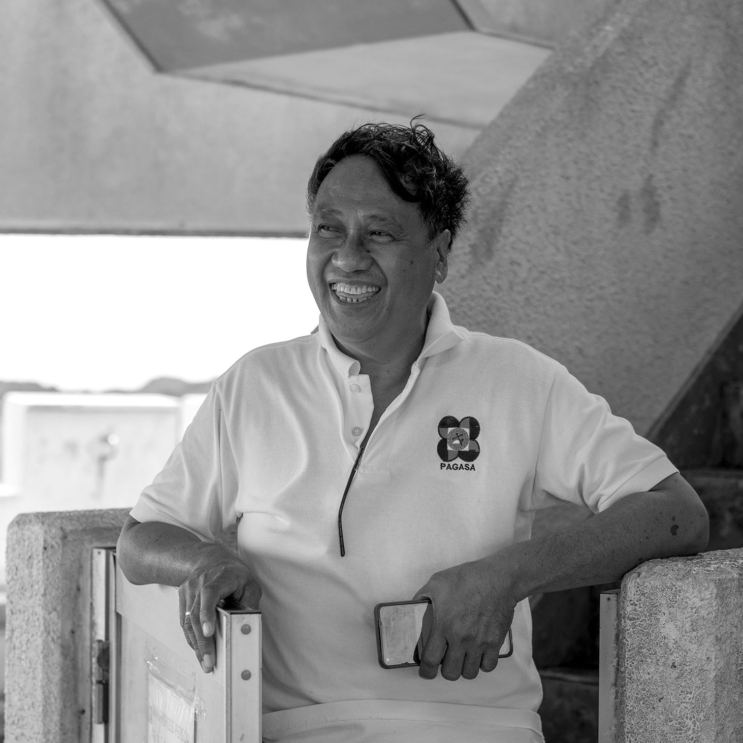
Marianito Macasa descending from the Doppler radar room at the Guiuan weather station. Photo by Mario Soriano.
Jane Delfino at her classroom at the Institute of Environmental Science and Meteorology. Photo by Mario Soriano.
Robert Sawi (left) and Jun Galang (center) interviewed by Mario Soriano (right). Photo by Braeden Carroll.
Episode 2: If We Called it a Tsunami
Carried by Water Episode 2: “If We Called it a Tsunami”
Full Transcript
Part 1. Storm surge
The night before Yolanda, primetime TV programming was interrupted by an urgent message from then President Benigno Noynoy Aquino.
He warned the public about the approaching powerful storm, and its associated threats, including strong winds, rain, overflowing rivers, and lahar or pyroclastic mudflows near some volcanoes.
The president also mentioned that experts were monitoring the threat of storm surges in more than a hundred areas, where waves may reach five to six meters.
He emphasized the importance of information, with statements like "Let me repeat myself: this is a very real danger, and we can mitigate and lessen its effects if we use the information available to prepare."
"If you already know that you are in a hazardous area, evacuate."
The president closed his five-minute-long message by invoking how no storm could bring the Filipino people to its knees as long as we were united. He wished everyone to stay safe in the coming days.
The broadcast ended with a list of five websites where the public could get additional information: PAGASA, the National Disaster Risk Reduction and Management Council, the government website, the Mines and Geosciences Bureau, and Project NOAH, or the Nationwide Operational Assessment of Hazards.
Project NOAH evokes the biblical figure who built a gigantic ship to survive the flood that engulfed the Earth over 40 days.
In 2013, NOAH was a fledgling initiative envisioned to become the country's 'flagship' disaster management program. It was launched in 2012 under the Department of Science and Technology (with government funding of 6-billion-pesos or over 100 million USD). Sticking to the ship analogy, Project NOAH's captain was a geologist and disaster scientist named Mahar Lagmay.
Lagmay: NOAH stands for Nationwide Operational Assessment of Hazards, which is the application of operations research into the decision making process of government to handle, to prevent and mitigate the impacts of disasters. We were embedded in the operations of the National Disaster Risk Reduction and Management Council, wherein we, as part of the academe, was allowed to participate in the discussions of how to assess the risk of an incoming typhoon using the frontier technologies, using the best available science, and apply it to the decision making process of the National Disaster Risk Reduction and Management Council.
The mandate of Project NOAH was to deploy the latest science and technology to generate and disseminate "hazard specific, area focused, and time bound" warnings to the public.
In days before Yolanda, NOAH scientists forecasting the storm's possible impacts were alarmed as they saw something unusual in their computer simulations.
Lagmay: I remember very clearly that two or three days before Yolanda made impact, the group informed me that there was something unusual about the simulation. So I looked at it and then recognizing that, yeah, it was unusual because these storm surges were about five to six meters in height, which was different from the other simulations that they were studying, which was only about one to two meters in height. Needless to say, we did action on that by informing the Secretary of the Department of Science and Technology. The moment that he heard about this, he called us with the head of the weather bureau of the Philippines, PAGASA. And we had the meeting and we discussed the simulations that were kind of strange. They were strange because they're quite high. Recognizing the secretary being astute in these things, and he would rather err on the side of safety than just ignore it. So he said that, oh, this is very important. We need to inform the president about this.
That’s how the President learned of the possible threat of storm surges from Yolanda.
Project NOAH’s simulations were also where the President got the 5 to 6 meter number for the height of the storm surges that he announced in that televised warning.
How high is 5 to 6 meters? Basketball legend Michael Jordan’s height is listed as 6 foot 6 inches, or 1.98 m, so 6 meters is about three Jordans stacked vertically. 6 meters is also the typical height of a 2-storey house.
Back in Tacloban, Mario Peñaranda said he had to climb to the roof of the then one-storey PAGASA station to avoid being swept away by the surge.
Peñaranda: I was holding the door because the strong winds, it would open. So when the storm surge came in, it was just like a spray because it was forcing through the space of the door. I made an attempt to open the door, but you can no longer open the door because both sides are already water. So I went to the window and when I saw the water that it was coming too fast, I broke the glass. I broke the glass. So I went out. My colleague told me not to go out, so I told them we will die here inside this room. So I went out and, because it's already survival, so I went up to the roof because I am afraid, I don't know how to swim. When I was already able to reach the roof, it was really zero visibility. I was afraid that the storm surge would hit over our roof.
Mr. Peñaranda said that, while he was aware of the threat of storm surge, he was still caught by surprise.
Peñaranda: I was not expecting that it would reach the station.
Not too far away from the station, Algina Lacaba had evacuated with her husband and three young children to the Brgy. 88 elementary school near their home.
Lacaba: I'm Algina Lacaba. I'm a plain housewife and hopefully becoming a teacher. My husband is just a dispatcher, a barker from the buses coming from Guiuan, Eastern Samar. I have three children. The eldest is about to enter grade 11, the second grade 10, and the youngest, grade 8. We have a school there near Fisherman, Brgy. 88. There’s a 2-storey building. That’s where we evacuated. It was close to where we lived. Most people evacuated to schools.
Just as with the Tacloban weather station, the storm surge overwhelmed the school evacuation center. The water carried Algina’s husband all the way to downtown Tacloban, near the Eastern Visayas Regional Medical Center, or EVRMC. That’s almost a 4-km distance as the crow flies.
Lacaba: Actually my husband was among the injured. Because from Brgy. 88, he was swept all the way to the old EVRMC. So from airport to EVRMC. That’s quite far.
Algina attributes her family’s survival to two things: having the right skills and not panicking as the water rose.
Lacaba: We survived because we had the skills. My husband and I, we knew how to swim. If we didn’t, you probably won’t be able to interview me now. There was chaos in the evacuation center when we were there. I didn’t panic because I knew how to swim. I just stayed calm while the people were running and hurting each other in their rush. My three small kids and I just stayed put, hanging onto a window as the water kept rising. In my mind, I’m convinced that we survived because we didn’t panic. My children didn’t panic. They didn’t cry. Because even when they were very young, because we lived by the sea, we already taught them how to swim.
Many were not as fortunate.
The National Disaster Risk Reduction and Management Council’s final report on Yolanda listed the official casualty count as 6,300.
Most of those deaths were caused by the storm surge.
Part 2. Terms of evacuation
In Yolanda’s aftermath, as people tried to find explanations for what happened, two narratives kept coming up. One was that people did not understand the term storm surge used in the warnings, so they were not able to take the necessary precautions. Second was that, regardless of the preparations that were made, Yolanda was simply too powerful and all the preemptive actions were rendered ineffective.
Bernadas: We had had experiences of storm surges before, but we never recognized it as storm surges. We simply recognized it as high tide together with the strong wind, although the waves would reach the city streets. But this time, the devastating, strong waves was really, so powerful, so powerful that any preparation we had was not equal to the strength that Yolanda gave to Tacloban city.
That’s Brando Bernadas. He’s currently the City Disaster Risk Reduction and Management Officer of Tacloban. His office, the City Disaster Risk Reduction and Management Office, is also called CDRRM (pronounced “sea-dream”) for short.
Back in 2013, Brando was working directly under the city mayor’s office. He was involved in the preparations made before Yolanda struck.
Bernadas: The night before Haiyan, I was assigned to monitor preparations of communities in the northern part of the city while the city mayor was supervising the preparation of the communities in downtown proper and the southern part barangays.
He said that it was difficult to convince some communities to evacuate.
Bernadas: Before Haiyan, we could hardly convince them to evacuate. They would simply say, well, we know what to do. We have been through our lives here. We know how this typhoon would impact us. We know where to go. Don't worry about us.
According to news reports of Yolanda’s aftermath, Tacloban City Mayor Alfred Romualdez suggested that using the word tsunami instead of storm surge might have convinced more people to evacuate and save their lives.
CNN reported the mayor stating, quote, “We’ve done drills on tsunami. And when we do (tsunami) drills, almost 80% of them really get out. Storm surge, they don’t understand.” end quote (https://edition.cnn.com/2013/11/12/world/asia/typhoon-haiyan-vignettes/)
For its part, PAGASA said it conducted education campaigns about storm surges in Tacloban before Yolanda. Here’s Jun Galang, who we met last episode.
Galang: PAGASA already do the IEC or information and education campaign on that area in Tacloban. Different hazards were communicated there, including storm surge. Their claim that they did not understand, they did not know the term storm surge, maybe for others. But we conducted the IEC or information and education campaign on that area itself.
Mahar Lagmay of Project NOAH said that science and public safety were their main considerations in their warnings.
Lagmay: We cried because we knew that there were going to be storm surges that would impact coastal communities in the central Philippines region. And we were helpless. We were even blamed because we should have called it a tsunami, but we could not do that because a storm surge is different from a tsunami. If we called it a tsunami the night before Yolanda made its impact, we could have killed people because the actions or the response to a tsunami is different from the response to a storm surge hazard. Storm surge hazards, you have time to move away. Tsunamis might create panic and then a stampede. And we didn't like to do that. So we retained the term storm surge, which unfortunately was not as well known as a tsunami. We had to stick with the science because we feared that we didn't want to kill people by calling it a tsunami.
Several of our interviewees in Tacloban recalled that, after Yolanda, a rumor spread that a tsunami was coming. Typhoon survivors, having just gone through what they had gone through, ran for the mountains. Of course, there was no tsunami. There was no earthquake to trigger one.
While the mental imagery and fear that warnings evoked would have certainly affected people’s decisions to evacuate, other factors were also at play.
Pamela Cajilig is an anthropologist who studied why some people did not evacuate during Haiyan. We spoke to her at a cafe in Quezon City.
Cajilig: I am Pamela Cajilig. I am an anthropologist working at the intersection of disaster risk reduction and management, climate adaptation, and architecture and design. I was interested in people who didn't evacuate on the day of impact in Yolanda. What were the different decisions that they had to make when they were experiencing the storm surge?
Pamela found that many people had a sense of security based on their previous experience of storms, similar to something Brando Bernadas said earlier in this episode. She also found that men’s sense of pride in their house also affected a family’s decision to evacuate.
Cajilig: In my research, the decision to evacuate whether a family should leave the house, is on the male head of household, usually the father. And if they had a hand in constructing the house, they almost felt like it was a sign of weakness and defeat to abandon the house that they built. It's like they failed in protecting their family. So there was some of that sentiment when we were talking to the women who had told the stories about how their husbands discouraged them from evacuating, even though they were already very afraid of the possible impact of the storm surge.
Pamela also noted the sense of helplessness in some communities when it comes to preparing for disasters.
Cajilig: There was this sense that if you're poor, then you have no chance against hazards like Yolanda. Like only the rich can prepare for disaster. So if you're poor, you're better off not doing anything at all. And I don't blame them for thinking this way. There's so much inequality in society that people are led to think that disaster preparedness is beyond reach.
In other words, people’s decisions on whether or not to evacuate during Yolanda were rooted in expectations beyond the warnings they received.
Sadly, evacuation was not even a guarantee for survival given Haiyan’s magnitude.
Brando Bernadas again.
Bernadas: Actually, we lost many of our evacuation centers to Yolanda because many of our evacuation centers were buildings and school campuses along coastal areas.
To be precise, 68% of evacuation centers in Tacloban were inundated by the storm surge, according to a study from Project NOAH.
How did this happen? Mahar Lagmay says the debacle can be traced to the fact that, while there was information about the possible height of the storm surge, the other key piece of information was not available at that time.
Lagmay: What we had then were forecasts of storm surge heights. We needed to reflect that absolute height into the different coastal landscapes of the Philippines. Some were full of cliffs, some were flat, and in places that were flat, the inundation would be so much more inland. Maps could have told us that the inundation could be two to three kilometers inland, depending on the landscape. We did not have those maps.
People did not have accurate information on the possible lateral extent of the surge. I stress the word ‘accurate’ on purpose. Hazard maps were available during Yolanda, but they showed storm surge inundation reaching only up to 50 meters inland, according to Lagmay. They did not capture Yolanda’s true inland inundation, which extended a few kilometers in some areas.
Maps created after Yolanda show that the peninsula containing the Tacloban airport was completely inundated by the storm surge. This is the same peninsula containing the PAGASA station, where Mario Peñaranda and his coworkers were, and the Brgy. 88 school building where Algina Lacaba and her family evacuated.
Part 3. A perfect recipe
Mori: When I arrived to Tacloban, Leyte and Samar area, where was the most devastated area, by Haiyan, I felt the scenery is very similar of what I saw just after the 2011 Tohoku earthquake in Japan. I've been many places after the tsunami or hurricane as a post disaster survey and, Tacloban was one of severely damaged area in my experience. And the scenery was very close to 2011 Tohoku earthquake-tsunami to me.
That’s Nobuhito Mori. He’s talking about what stuck out the most to him when he went to Tacloban in January 2014, about three months after Yolanda.
Mori-sensei is a professor of coastal engineering at the Disaster Prevention Research Institute of Kyoto University in Japan. I caught up with him at the conference of the Asia-Oceania Geosciences Society in Singapore.
Mori’s group had been developing a simulation model for predicting storm surges for several years, but they have not had a real world case to validate their model.
Mori: We have been working on the storm surge and extreme ocean modeling since last 25 years. So, we had a model to predict, but we didn't have a case study to validate our model.
Haiyan proved to be that very rare case that could test the accuracy of those model’s predictions.
Mori: We went to Philippine after the Haiyan to validate our existing model for extreme storm surges. This is because extreme storm surge is a pretty low frequency event. Extreme storm surge exceed the water level over more than two or three meter are very low frequency. So we want to check our model to predict inundation by the storm surge. Unfortunately, typhoon Haiyan inundated over the Tacloban area, which maximum water level was higher than maybe four or five point meter. Such kind of event is pretty rare. So we want to validate our model.
Mori was part of a post-disaster survey team jointly organized by the Japan Society of Civil Engineers and the Philippine Institute of Civil Engineers.
The survey team documented the storm surge height and the extent of inundation from debris and water marks on the landscape, alongside eyewitness accounts from survivors. Maps of their measurements started to unveil distinct patterns in Haiyan’s destruction.
Leyte Gulf is the body of water bounded by Leyte island to the west, and Samar island to the north. The gulf narrows into the San Pedro Bay as one approaches the closest point between the two islands. The bathymetry or depth of the bay is also quite shallow.
This geography and bathymetry amplified the storm surge generated by Haiyan’s winds in the towns along San Pedro Bay’s coast.
Tacloban city is at the tip of the funnel-shaped bay.
Mori: In Haiyan Tacloban case, wind brought over 60 to 80 meter per sec over the gulf of Leyte so it can cause a severe increase of the water level by wind. Additionally, Tacloban area, bathymetry is very shallow. And storm surge height by the wind induced surge is inversely proportional to the water depths. So, a shallow water environment near the Tacloban area also amplified the storm surge very much.
Storm surge height by wind induced surge is inversely proportional to the water depths.
In other words, the shallower the water, the easier it is for strong winds to push it up, creating higher storm surges.
Phillip Lapidez, Project NOAH’s lead storm surge modeler back in 2013, echoes the unique combination that comprised Yolanda.
Lapidez: The situation in Tacloban was a perfect recipe for disaster. You have one of the strongest typhoons that ever made landfall in combination with this coastline shape that is very conducive to generating extreme surges. If you look at the map, you will see that the shape of the coast is like a funnel. So what happens is as the surge propagates near the coast, the volume of water is being funneled into a small area and thereby increasing the surge levels. There are a few other regions in the Philippines that have similar characteristics, but Tacloban, especially in this way. And that's why it was a perfect combination of situations that led to this very rare event.
Haiyan was indeed a very rare event. However, it was not unprecedented.
Part 4. History repeats itself
Soriano: Good afternoon, Dr. Soria.
Soria: Good afternoon, Dr. Soriano.
I’m meeting Lea Soria at the AOGS conference.
Lea is the first author of a 2016 paper titled “Repeat storm surge disasters of typhoon Haiyan and its 1897 predecessor in the Philippines” published in the Bulletin of the American Meteorological Society.
Soria: I found out that there was a historical document about a storm surge in 1897 in the islands of Samar and Leyte.
The document in question is El Baguio de Samar y Leyte, or The Typhoon of Samar and Leyte 12th-13th of October 1897, written by the Jesuit priest Padre José Algué (https://nla.gov.au/nla.obj-2940095963/view?partId=nla.obj-2940217808).
Soria: Typhoon Yolanda and the 1897 Typhoon are almost the same in terms of the path. Apparently they went through the same path, like, few kilometers south or north of each other. Yolanda was a little bit stronger, but that 1897 is also a strong one. So that's a hundred year record.
Historian Ambeth Ocampo wrote about the Algué document in his November 19, 2013 column for the Philippine Daily Inquirer (https://opinion.inquirer.net/65685/tacloban-not-once-but-thrice).
There, he also cited coverage of the October 1897 event in an Australian newspaper which read “Typhoon and tidal wave in the Philippines. 7,000 lives lost.”
Ocampo also referenced a November 1912 article in the Washington Herald, during the period when the Philippines was under American rule. The headline: “15,000 die in Philippine storm.” The reporter wrote, quote, “The typhoon swept the Visayas and is said to have practically destroyed Tacloban, the capital of Leyte.” end quote
This history shows us that, with Tacloban’s geography, all that’s needed is the right storm to trigger destructive and deadly storm surges in the region.
In fact, Lea Soria’s paper listed seven other storms that generated storm surges in the Samar and Leyte region between the 1897 typhoon and Yolanda.
She says we might find more by looking at another kind of record: the sediments.
Lea is a sedimentologist. In her work, she searches for the fingerprints of disasters through the sediments that they deposit. She found such a record of Yolanda in the quiescent soil of a mangrove forest in Tanauan, a coastal town along the San Pedro Bay, about 20 km south of Tacloban city.
Soria: Imagine a wetland area that is dominated by mangrove species. So it's quite a muddy environment and the soil there are very, very fine grained sediments. And then here comes the wave from Typhoon Haiyan. It's a high velocity flow, so it carries a lot of sediments from the near shore area, that means anything that the wave can touch. And in Tanauan, which is south of Tacloban, that substrate is mostly sand. And on the beach area, it's dominated by magnetite rich sand. So that's the black sand. When we went there and collect sediment cores, we saw this 10 centimeter thick, well sorted sand layers on top of the mangrove soil, so we know exactly that it come from typhoon Yolanda.
Out of curiosity, I asked her how she collects the sediment cores.
Soria: We have either a metal pipe or a PVC pipe that just manually push down to the level that we can possibly reach because we do it manually. We don't have a special machine to do it. Most of the cores that we collected so far, at least in that Tanauan area is at least one meter long. The longest was 1.6 or 1.8 when we went there very recently. So yeah, just manually pushing down a PVC or a metal pipe, then taking it out again. So you have a whole sequence of sediment layers there.
She would then examine the sediment core in the laboratory, looking at physical properties like color and grain size distribution, and do tests to determine how old each sediment layer is.
Lea says records such as the Algué report are helpful to validate or cross-reference with the sedimentological record. She adds that the sediments can potentially offer a longer window into extreme events of the past and help us better understand the future of extreme events under climate change.
Soria: When you're studying climate change, you need to have a long, long record. Extreme events are called extreme events because they occur in such a way that it's very intense, but then they occur very rarely. For example, a Typhoon Haiyan scale occurs only with a hundred year cycle. So if we can look at the sediments and see longer records, we might be able to capture even larger events than Typhoon Haiyan.
Part 5. Searching for safe ground
So how have these factors of geography, and history been considered in the recovery effort in Tacloban?
One response has been to come up with better evacuation protocols.
Walking around downtown Tacloban, one can’t help but notice the ubiquitous signs identifying “Storm Surge Prone Area” or “Flood Prone Area” and arrows pointing to nearby evacuation centers.
Brando Bernadas from the Tacloban CDRRM office.
Bernadas: Before Haiyan, it was simply more on putting people inside safe buildings, jam-packing buildings just to accommodate temporarily displaced individuals. But after Yolanda, we learned so much as to how we should conduct our evacuation operation. Now, our evacuation plan is on a preposition protocol. We count in this particular area as to how many would be evacuees, and we provide household heads with color coded IDs to correspond color coded evacuation centers. In other words, our evacuees now are prepositioned. They know where to go. If your ID is color green, you cannot be accommodated in a color red evacuation center because your names are not found in that evacuation center. If ever you go to a different colored evacuation center, we will bring you to your proper evacuation center. This is how we do the evacuation operation now.
The city is trying to prevent jam-packed, overcrowded evacuation centers through this color coded scheme.
Colored in purple in this system are Brgys. 60, 60-A, and 61. Their designated evacuation center - the Tacloban City Convention Center, also known as the Astrodome.
The Astrodome was used as an evacuation center during Yolanda. It sits along the coast of the Cancabato Bay, and the waters of the storm surge rushed into the space during the storm. Despite sustaining damages from Yolanda’s winds, the building remained standing.
Our team visited the Astrodome earlier this year. You’ll hear the voice of my colleague, Patrick Jaojoco and then myself.
Jaojoco: It's July 23rd, 2023. We're here in the Astrodome in Tacloban, Leyte. We're inside the main hall or space.
Soriano: What do you think they're doing, setting up some kind of stage or something?
Jaojoco: Yeah. Or breaking down. I think they're breaking down the stage.
Soriano: A couple of days ago, we had passed by, there were graduation ceremonies being held here, so that’s why we had to postpone our plans to come in. Ah, maybe that's what the stage is for.
Jaojoco: Probably, yes.
We move closer to the center of the space.
Jaojoco: Okay ba? Some of the workers breaking down the stage are swinging from a very long rope hanging from the ceiling. Laughing. Having fun.
Soriano: Yeah, I guess, maybe it is signs of recovery that this space is being used for celebratory events, celebrations, milestones, and such. It's not like this has been frozen in time. Indeed, it is hard to see traces of the Typhoon Yolanda’s impact in the space right now.
Other than the main event hall, offices, shops, and worship spaces also line the exterior of the Astrodome. It remains an important center for the community in numerous ways.
We’re now in one of the upper rows of seats. We reflect on how it might have been for the survivors who evacuated here during Yolanda. Evacuees who had nowhere to return to were forced to stay in the Astrodome for days.
Soriano: There's about 14 levels of seats here. What we heard was, the first phase of the storm, when the wind was more of the threat, people were in the lower levels. And, once the threats were coming from the surge, people moved to the higher levels of the Astrodome.
Jaojoco: The structure was intact during the storm, largely, right?
Soriano: Yes, that's right. I think it was, one section of the roof blew off, but otherwise, it's intact. Still, this is just a circular space. So it's just rows and rows of seats. Not the most ideal for evacuation conditions in terms of basic facilities for sanitation, privacy, families, and stuff. So you can just imagine, maybe the people were just kind of waiting here.
Brando Bernadas told us that the city is in the process of upgrading its evacuation centers.
Bernadas: We were not following the national standard on humanitarian care on displaced individuals. We simply put people inside safe buildings. As we are preparing to upgrade our capability, we also are upgrading our evacuation centers. We are constructing buildings solely dedicated for evacuation, so that at any time when evacuation calls for the utility of these evacuation centers, they are already prepared.
A number of our Tacloban interviewees said they have yet to see these new, dedicated evacuation centers.
Another strategy the local government implemented was to move people away from the coast. In December 2013, just a month after Yolanda, the Tacloban City Council passed an ordinance designating coastal areas within 40-meters of the shoreline as No Build Zones. (https://www.sunstar.com.ph/more-articles/tacloban-passes-40-meter-no-build-zone-ordinance)
Views are split on this No Build Zone policy.
Algina Lacaba and her family were resettled from Brgy. 88 to a village almost 20-km north. She says she appreciates the government’s effort to transfer people away from the coast.
Lacaba: The city government tried their best to remove people living along the coast. I think that’s the best thing they’ve done. Not everyone can appreciate it. But I think that’s one good thing the government is doing because at least if no one lives there, maybe there will be less impact if there’s another deluge like that.
Mahar Lagmay questions the adequacy of a uniform No Build Zone.
Lagmay: Again, this is not learning the lessons of Yolanda. We know that in some places the inundation was three kilometers. That blanket No Build Zone is b******t. It does not mean anything in terms of storm surge hazard. It does mean something if we're talking about easement, where people can bike or people can walk, but it does not mean anything in terms of the big hazards that we are discussing. The Yolanda type of hazards. The No Build Zones must be based on hazard maps that are produced from the best available technologies and the best available science. I'm sorry for my French.
Phillip Lapidez echoes the importance of basing policies on rigorous science.
Lapidez: The concept of No Build Zones in the Philippines should be updated. Currently, there exists some guidelines that sets a static number, a static distance from the coast that sets a certain area as No Build Zones. But this should be a dynamic criteria in a sense that each coastline is different and so the No Build Zone should also be different. This should be based on empirical evidence and the probabilistic nature of the coastal hazards.
From 2012 to 2017, Project NOAH created high resolution, multi-scenario, hazard maps for the entire country, not just for storm surge hazards but also for floods and landslides. The government discontinued its funding in 2017, and the program is now housed under the University of the Philippines Resilience Institute. The hazard maps that the program created are freely available through NOAH’s website.
The Tacloban CDRRM Office is filled with large hazard maps, although they are not the ones from Project NOAH.
Bernadas: These hazard maps are rectified hazard maps, because the old hazard maps were not really the reality of hazards in Tacloban City. That is why these are new ones, because these were rectified by map experts that came from international communities or international agencies. For one is Habitat for Humanity, USAID, who had map experts, mappers. We have provided all these maps to barangays, wherein we are also convincing the barangays to localize their hazard maps, come up with their own hazard maps guided by these generalized Tacloban city hazard maps. And a lot of these maps are already distributed in the academe, schools because one of the many impacts of Haiyan is that schools have started to mainstream, integrate this into their core curriculum, disaster risk reduction and management.
Pamela Cajilig brings up a different but equally important dimension to the question of no build zones.
Cajilig: I actually have a picture of that No Build Zone sign, where someone who obviously used to live near that sign, painted over the ‘No’. So that the sign had ‘Build Zone’ on it, and then they built a house next to it. I am an advocate of participatory approaches and for me, they should have consulted the people who would've been affected by that No Build Zoning rather than just implementing it and displacing people who were already affected by a disaster.
Algina Lacaba also notes that, while moving people away from physical hazards is important, authorities should also make sure that people can live decent lives.
Lacaba: Not everyone here has a job. Most of us here used to be fishermen. When you transfer people like fisherfolk away, you have to also provide them with a livelihood that’s sustainable.
The government’s strategic plan for recovery was outlined in a December 2013 document titled ‘Reconstruction Assistance on Yolanda’. The backdrop of the cover page was a map of the Philippines showing Yolanda’s track and highlighting the provinces affected. Four stick figures were raising a flag and three were shown in various construction activities. There, at the bottom of the cover page, were the words Build Back Better.
Ten years have passed since Yolanda. How has the reconstruction effort unfolded? Have the impacted communities returned to a state of normalcy? How have these communities navigated the complex and contentious process of rebuilding?
Atienza: It's not enough to just build houses or move people to safer ground. You also have to make sure that people have access to services, they can work, there are facilities. And one of the complaints in those areas is that it's difficult to find work in those areas.
Next episode, my colleague Patrick Jaojoco takes us through disaster recovery.
Carried by Water was created by me, Mario Soriano, and is a production of Blue Lab at Princeton University. This episode was produced by me, along with Patrick Jaojoco and Braeden Carroll. It was mixed by Braeden Carroll. Thanks to Cassie Eng from the Princeton Filipino Community undergraduate club for providing voiceover for this episode. For their support and expertise, we also thank, at Princeton, the High Meadows Environmental Institute, Humanities Council, and Office of the Dean of Research as well as Kouvenda Media.
Allison Carruth is the director of Blue Lab, and Barron Bixler is creative director.
Visit our website, bluelab.princeton.edu, for more information and photographs for this episode.
Until next time.
~~~END OF EP02~~~
Super Typhoon Haiyan seared the meaning of “storm surge” into Filipino minds, but in 2013, authorities were criticized for using this term instead of “tsunami”, which was more familiar at the time. We hear from disaster scientist and Project NOAH director Mahar Lagmay on what went into the public warnings for the storm surge. Survivors Mario Peñaranda and Algina Lacaba recount their firsthand experiences of the surge in Tacloban City, and Brando Bernadas reflects on the city's efforts to improve its disaster risk reduction and evacuation protocols since the storm. Anthropologist Pamela Cajilig shares how pride and poverty influenced people’s evacuation decisions, and Nobuhito Mori, Lea Soria, and Phillip Lapidez shed light on the particular geography and history that make Tacloban vulnerable to catastrophic storm surges.
A motorcyclist rides past flood and storm surge warning signs in Tacloban, Leyte. Photo by Mario Soriano.
Lea Soria describing a sediment core in Tanauan, Leyte. Photo by Mischa Haas, courtesy of Lea Soria.
Tacloban City Convention Center, a.k.a., Astrodome, functions as a multifunctional event space and evacuation center. Photo by Mario Soriano.
Signs for the color-coded evacuation scheme and cyclone and storm surge warning systems displayed in the Astrodome. Photo by Patrick Jaojoco.
Episode 3: They Said that Cancabato Bay is Already Dead
Carried by Water Episode 3: “They Said that Cancabato Bay is Already Dead”
Full Transcript
Hey, it’s Mario. We’re doing a little switcheroo. We’re saving our conversation about the Yolanda resettlement experience for a later episode. Instead, today’s episode centers on coastal infrastructure and nature. I won’t say too much, but I’m really excited to share these stories with you all. Okay. Here’s the episode.
(Intro music starts)
From Princeton University’s Blue Lab, this is Carried by Water. I’m Mario Soriano.
In today’s episode, we center our conversation on stories about non-human elements of the Yolanda experience.
We’ll hear about the government’s response in terms of hard coastal infrastructure. We’ll also talk about Yolanda’s impacts on nature, and, vice versa, nature’s role in mitigating the impacts of extreme weather. We’ll then talk about the unseen but critical resource that is groundwater, as well as the threat of seawater intrusion in coastal aquifers.
Episode 3. They said that Cancabato Bay is already dead
Part 1. Concrete adaptation
As we mentioned in a previous episode, the government adopted the mantra, “Build Back Better” in its vision for reconstruction after Haiyan.
We asked Brando Bernadas, Tacloban’s City Disaster Risk Reduction and Management Officer, what this phrase meant for him.
Bernadas: One of the evidences of the imposition of Build Back Better: the tide embankment. These were supervised by the JICA and the DPWH.
JICA stands for the Japan International Cooperation Agency, and DPWH is the Department of Public Works and Highways, a national government agency.
Bernadas: Look at them. It's a big help. The tide embankment, if you visit the tide embankment, we had proven it very effective. Why? Because it was constructed through the standard of build back better. But the problem is how to maintain it. This is constructed along the coastline and you know how seawater can erode this structure. In fact, DPWH just recently told us that they are now about to turn over those projects to the city government for the city government to give a budget for the maintenance of those structures. And we are willing to do it as much as we can afford because we had proven it is a good defense against future devastating waves from the sea.
The tidal embankment is a 4-meter-high concrete wall constructed along the coastline of Leyte Gulf.
Design documents from JICA show that the embankment is meant to protect coastal towns from storm surge events with a 50-year return period. The report states, quote, “Storm surge of lower frequency, as was the case of Yolanda, shall be protected by non-structural measures” end quote. These “non-structural measures” include evacuation planning. (https://openjicareport.jica.go.jp/pdf/12283420_02.pdf)
If you recall from our previous episode, Yolanda has a return period of about a hundred years. One study estimated the return period to be at least 240 years (Kumagai et al., 2016). These numbers are based on statistical probabilities, so the interpretation of a 100 year return period event is, for any given year, that event has a 1-in-100 probability of occurrence. The tidal embankment is designed for events with a 1-in-50 chance of occurrence for any given year.
Construction began in 2016. The embankment was originally planned to run a length of 27.3 km along the towns of Tacloban, Palo, and Tanauan. At the end of October this year, the Philippine News Agency, the government’s official newswire service, reported that the planned embankment has been expanded to span 38.12 km. It also reported DPWH stating that the project was about 59% complete. Costs are estimated at 12.14 billion pesos or 216 million US dollars. (https://www.pna.gov.ph/articles/1212825)
The project, which has also been dubbed the “Great Wall of Leyte”, has faced opposition from local groups based on a lack of adequate consultation by the DPWH, and unclear government plans on livelihood support for the people who would be displaced. (https://www.calbayogjournal.com/dpwh-s-tide-embankment-project-continuously-opposed; https://www.leytesamardailynews.com/tide-embankment-project-only-at-60-completed/; https://www.change.org/p/president-rodrigo-duterte-stop-the-tide-embankment-project)
The embankment is located 30-meters from the shoreline, so it falls inside the 40-meter No Build Zone, where the government has banned residential structures.
Yee: Actually, the no build zone is demarcated by that embankment, meaning if the embankment is built, then technically that's the no build zone. And so in a way the policy is concretized physically.
That’s Dakila Yee. We spoke to him at a coffee shop in downtown Tacloban.
Yee: My name is Dakila Kim Yee. I am a faculty member at the University of the Philippines, Tacloban College. I'm a sociology teacher, but I actually dabble a lot with geography literature. And, I have been, uh, doing research on disasters, disaster recovery after Yolanda.
Dakila grew up in Palo, just south of Tacloban. He was at grad school in Manila when Yolanda hit, but his family was at home.
Yee: They were actually swimming in the storm surge waters. That's somewhat strange for us because our house is very far from the sea, one to two kilometers away, although we are near a river. And so the waves, like, the story of my father is that it climbed up the river tracks. It was life and death situation for my family who was left behind. And that's why it's a bit strange for me also to talk about Yolanda because of the outsider dynamic, cause I wasn't really here.
Dakila told us that the implementation of the No Build Zone policy has been an extended process of renegotiation between people and the government, and between people and their environment.
He said that, unlike what happened in the aftermath of the 2004 Indian Ocean tsunami, where people living in newly designated No Build Zones or Buffer Zones were mandatorily relocated almost immediately in countries like Sri Lanka, Indonesia, and Thailand, the experience in Tacloban has been more prolonged.
Yee: Immediately after Yolanda, some people were already anticipating no build zones. At this point, some of the sites have been cleared. But you know what actually it has taken like from 2013 to 2023, it's really been a long process. People have been renegotiating it on their daily terms. If they can go back, if they can come back. Some employees in the government that I've talked to before said that, well, we know that they are coming back to the no build zones, but we don't want them to lose their livelihood. So they're somewhat also understanding of the situation. I think that the implementation or the renegotiation of the people in the communities somewhat happen on a day-to-day basis. It's really trying to renegotiate: if you know the local barangay captain, if you can get into their good side, you can, or if they can buy you time. "Just let us stay here for a while." So it's really like buying time.
Many of the people living in the no build zones were fisherfolk or people employed in other industries dependent on the sea. They have been or are in the process of being relocated to resettlement housing communities further inland, some about 15 km north of downtown.
Yee: I've interviewed a lot of fishermen. It's not just the fishermen, but also vendors, those who are reliant on the fish trade. They had the same problem: the proximity to the market. Here they can just walk to the market. The cost is really low, but now they're paying 50 to 100 per day. So those are some, some of the daily costs of resettlement.
For a bit of context, the minimum wage for people in the agriculture sector in Leyte is 345 pesos per day, so those transportation costs from resettlement areas can be a significant portion of one’s income.
We’ll talk more about resettlement in a later episode.
Dakila told us that the presence of the tidal embankment, which also functions as a bike and jogging lane, presented a new dynamic in these communities.
Yee: You can go to San Jose, the area near the airport. If this is the embankment, this is where the houses are, the road, the houses, and then their boats are here and then the sea. So they couldn't bring the boat anymore because of the height of the embankment. And so you can see how the people have adapted to the existence of a climate change infrastructure, because it's to stop the storm surge from coming in. But it's actually interesting because they have promoted it as a bike lane. People are jogging there, people go there for beach outings. But also you can see people unloading fish, so you can see it, you can see it there. It's a really interesting dynamic.
We learned of another controversial infrastructure project while we were in Tacloban.
Mangada: It was just stopped. They're going to reclaim the whole area of Cancabato Bay. Some people, especially the young and few academics really put up a good fight in the city council to stop the reclamation. But apparently, because there's already budget, it's going to push through.
That’s Ladylyn Mangada. She’s a political scientist at the University of the Philippines in Tacloban.
Mangada: I think I've been teaching for 30 years or more. As a faculty of, uh, UP, before Yolanda, my research and public service activities were centered on the local politics. It's about elections, it's about the dynasty rule here in our place. But when Haiyan hit us, my research interest was diversified to Haiyan-related issues. So that's the reason why a lot of my activities are related to Haiyan or climate change or restoration, protection of the environment.
Ladylyn is also a survivor of Yolanda’s wrath in Tacloban.
Mangada: It was really very strong. Very, very strong because after the typhoon, I went out of the house. Oh my god, all the trees fell. When I was able to go out and went to look around, that's where I saw the zombie, zombie faced people. People were like zombies, that people were, were just confused, panicked. And I saw the devastation.
Coming back to the present, Ladylyn said that the local government had been promoting reclamation as a development and adaptation strategy.
Mangada: They say that one of the best response to storm surge, to mitigating these things is, uh, reclamation. The first part is they're going to construct the causeway from here to the airport. After that, they're going to reclaim. And they said, that would be the central business district of Tacloban. They're going to put up the big buildings there because they said that Cancabato Bay is already dead, so they're going to reclaim it.
We’ll hear more from Ladylyn in later episodes.
The DPWH describes the causeway as, quote, “The P3.46-Billion project will involve the construction of a 4-lane road embankment measuring a total of 2.56 kilometers, a bridge spanning 180 meters, with the provision of a separate bike lane, installation of concrete canals, sidewalks, and wave deflectors on both sides. The project is expected to offer an improved travel experience that will soon cater motorists opting for a scenic drive, as well as pedestrians who prefer walking, running, and biking. The causeway was designed to withstand disasters and high humidity while also offering protection to nearby communities against erosive tidal movements caused by weather disturbances.” end quote (https://www.dpwh.gov.ph/DPWH/news/28315)
Dakila Yee says that these plans reflect a continuing focus on physical infrastructure in government priorities.
Yee: The initial plan was the coastal no build zones was gonna be a green belt, but of course it could not be implemented. The city continues to prioritize concrete forms of development. So actually, there's a proposed causeway connecting this part of the city to the airport. As you can see, the plans are still really infrastructure driven. There has to be a different way for promoting development. Thinking about development as something that is connected to the generation of risk is still something that is not appreciated. And that is where the next work needs to be done.
Part 2. Mangrove resistance
Mangroves soundscape
We’re at the Paraiso Mangrove Eco-Learning Park Marine and Wildlife Sanctuary, a mangrove forest located in Brgy. 83, Paraiso, along the Cancabato Bay. As you might guess, the village name, Paraiso means paradise.
Roque Regis, or Mano Roque, is telling us about the different types of mangroves in the forest. Rhizophora apiculata. Avicennia rumphiana. Aegiceras corniculatum. And several others.
Roque: This eco-park is around 10 hectares. This is the only area in San Jose with mangroves. This place used to be my playground when I was young. I was born in 1965. I never left Tacloban. It’s beautiful here. But this causeway that they’re building, it’s going to block the flow of the current… If they build that, this place will die.
Mano Roque is part of the cooperative maintaining the eco-park. Joining him during our interview were Mana Milagros and Mana Hilda. Mano and Mana are honorifics for elderly folks in Waray, the local language.
Also with the three of them was the cooperative’s cat, Mingming, who you’ll hear in the background.
Gilda: I am Gilda. I am a widow. I have four children who are all grown up. Perhaps that’s why I became active in our eco park. I needed something to be occupied with. *laughs*
Milagros: I am Milagros. I have nine children. I am also a widow and a founding board member of our cooperative. With my age, I prefer to go here, to the mangroves. It keeps me occupied. Like what my grandchild says, it’s too boring for the elderly to stay at home all the time. I am able to stay active here. Both of us, actually. We seem to be the most active elders here because the others always rest, and I mean always. We even have two other elders who have rested eternally with God. This keeps us active.
The members of the cooperative are residents of Barangay 83, which suffered only 23 casualties from typhoon Yolanda. Gilda and Milagros told us that the mangroves that were there played a key role in that small number of deaths.
Milagros: This mangrove park started after Yolanda. But even before Yolanda, there were already some mangroves here. There were even some houses here. After Yolanda, around 2015, we started to really take care of a particular kind of mangrove found in the area. This mangrove helped our people during the super typhoon. Come to think of it, if it weren’t for this type of mangrove, a lot more people would have died. Because of this mangrove, there were only 23 casualties from our barangay. The cars that got washed away couldn’t pass through. Our mangroves trapped them. That’s why our mangroves are very important to our barangay. We treasure these mangroves.
Mano Roque later took us to the spot where the mangroves trapped a 20-foot container van that was being carried by the incoming storm surge from somewhere across the bay.
Roque: This is what Mana Gilda and Mila were talking about earlier. This is where one twenty-footer container van was trapped by mangroves. There were others too, but this area, we decided not to plant anymore. We just use it as a corridor for boats and floating cottages. We put them inside the forest when there are storms. And we also showcase that a twenty foot container van was trapped here.
Without the mangroves, such large debris would’ve reached their village, potentially killing more people.
The cooperative started as a way to replant the mangroves that were destroyed by Yolanda.
Milagros: After Yolanda, a lot of the mangroves died. Our barangay captain then devised a plan to replant and restore their abundance. We conducted a lot of potting for the seedlings. We were quite small when we started. Most of us came from the barangay. We were around 25 members—health care workers, barangay security personnel, barangay officials, and some caring residents. When we were starting out, a part of our barangay captain’s plan was a nursery for the mangrove seedlings. It’s a beautiful nursery before. Many admired the nursery. Our barangay captain grouped us together and gave us designated areas to create the nurseries. We even had some friendly competitions, which plant was the best, which mangrove was the cleanest, and a lot more. It was such a joy starting out. We started as a smalltime organization. By 2019, people from city hall paid us a visit and advised us to create a cooperative. Our barangay captain liked the idea and now, this is it. We’re a recognized cooperative of the city. How it works now is that the cooperative handles the day-to-day operations, the planting, the taking care of the vicinity, and ensuring the cleanliness of the place. But the actual space and all the other facilities within the area belong to the barangay, barangay eighty-three.
The cooperative was formally established in 2019 with 25 members. Two have since passed away, so their current number is 23. All of the members are volunteers.
Gilda: We operate on a voluntary capacity. We do not have incentives, nothing. We are really in survival mode at the moment.
Milagros: It’s funny come to think of it. We’re beyond our youth yet we’re the most active. *laughs* That’s the situation here. Volunteer. Always volunteer. *laughs* My nephew always says this, “Is there no younger person that takes action?” *laughs* I always reiterate that I’ve been in 30 years of service, and this is my lifestyle.
We ask them why they continue to volunteer for the mangrove cooperative.
Gilda: It’s really hard. But we do with what we have. We’re already happy even if we just see fishes swimming by the water.
Milagros: Then in the afternoon, birds of different colors visit the mangroves. You see, mangroves are a sanctuary for fish eggs and a nestling place for birds. Before Yolanda, we never saw birds in the mangroves. They may have gone far because little to none was left of the trees. When our plants grew, different kinds of birds arrived.
Gilda: Sometimes, when we lounge around in the afternoon, we can spot several kinds of birds. Even with my sixty-six-year-old eyes, I can still see the abundance of colors of these birds. In the afternoon, the leaves even seem to fly. We take photos of these mundane things to show people that beauty exists in the mangroves. Look at that mangrove arch, we planted that and now look, it’s grown big. It looks like a cave. You see, those little things make us happy.
Mano Roque adds that visiting researchers have also taught them about the role of mangroves in carbon sequestration.
The Paraiso Mangrove Cooperative is part of the Cancabato Collective, which opposes the causeway project and the reclamation of the Cancabato Bay.
Milagros: No build zone areas should have mangroves that serve as natural embankment when there are strong typhoons. Right now, the embankment that the government wants to push for is the causeway project. Our mangroves right now have a life of only five years. Why? Because of the causeway project. We are against the causeway project. Causeways are only okay when they do not occupy the sea. Look at San Juanico Bridge, it does not destroy the natural order of things. Our local government unit plans to fill the sea with land and build a road that connects to the airport. How pitiful for the mangroves.
Roque: The most pitiful is actually the environment. The most affected are us. When you build that thing, people will have no more fish to eat. Our government speaks of climate change when in fact, it should be advocate for climate justice. Where is climate justice there? Cancabato Bay will be filled with land. Where is the justice there? There is no climate justice there. When that area is filled with land, there will be no more cool sea breeze. The air will be dry and hot. Right now, the air is cool because it comes from the sea. People will not benefit from that. The people that will benefit from that are rich businessmen. People from other nations invest in this plan. We will not benefit from that at all. That’s a sickness of the Filipino. Even when your neighbors are in danger, you do not think of them. In other nations, they protect their elders. Their spaces, they protect.
Milagros: If you have friends from other nations that have the capacity to help, please endorse our cooperative. Tell them our story, of the old people from Paraiso Tacloban that take care of these mangroves. Hopefully, they will feel our sincerity and help us. Tell them our story.
A couple of weeks after our team left Tacloban, the city council gave its nod for the causeway project to proceed. The Philippine Daily Inquirer reported that the DPWH was given the green light after making design modifications to address concerns about the environmental impacts of the project. (https://newsinfo.inquirer.net/1816549/tacloban-council-drops-objection-to-p4-b-causeway-project)
I asked Nobuhito Mori, the professor of coastal engineering we met in Episode 2, to compare mangroves against concrete structures for coastal protection.
Soriano: Could you maybe compare a mangrove versus a more traditional structure, like a sea wall or embankment?
Mori: Yeah, comparing so-called gray and green for us. Gray means a sea wall by made by concrete or soil, and the green means a mangrove forest in this discussion. So gray is more reliable because we know the engineering function like the maximum load can sustain, and how much wave force can reduce by concrete seawall. On the other hand, gray infrastructure is expensive to make. That is a maybe problem, for some developing countries. On the other hand, green is very cheap compared with gray infrastructure. However, we don't know much about engineering function of the green infrastructure. Additionally, a mangrove forest green infrastructure is zero in the beginning. We have to put a mangrove forest from the seed, and we need to wait, 10 to 20 years after the installation of the mangrove. It is also challenging how mangrove forests can be grown in time with increasing engineering function. So, gray is very short, expensive, and one time installation. But green is cheap but need to maintain for a long time and it's also time dependent. So that is a kind of major differences between them. Mangrove is a part of nature-based solution for coastal protection. And I believe it's very useful for developing area especially in East Asia and the Pacific Ocean Islands.
Mori is currently developing guidelines on the engineering functions of mangrove forests in his research. How long, how wide, how dense should mangrove forests be? How can we grow the forest to keep up with rising seas and changing conditions in the future?
Perhaps, local mangrove cooperatives can fill the important role for the long term maintenance required by mangroves to properly serve their coastal protection and other ecological functions.
Part 3. Reef stronghold
We now venture seaward to a different ecosystem on the frontlines.
Soriano: Could you tell us about this room we’re in right now?
Anticamara: Ah, this is a very special room. This is part of the UP Diliman Invertebrate Museum, which I am curating. And some of the specimens that you're seeing are mostly type specimens of corals found in the world and found in the Philippines, which is the basis for the identification of some of the species of corals that are found throughout the Philippines and the tropics in particular.
That’s Jonathan Anticamara, a marine biologist.
Anticamara: I'm Jonathan Anticamara. I am a professor here at the Institute of Biology in the University of the Philippines, UP Diliman, and I do research mostly on coastal marine ecosystems, in particular coral reefs in the Philippines, looking at fisheries, coral restoration options and assessment of biodiversity, and how we can manage those reef biodiversity in the country.
I ask him how important coral reefs are.
Anticamara: Very important. So in the Philippines, basically the coral reefs are, if they're healthy, they're a secured, stable source of food, income, livelihood for many Filipinos. That's really their importance. But the other thing I think on top of that, most people don't recognize that coral reefs, because they are really sturdy structure and they're on the coast, they actually serve as a protection from surge. So they're the first kind of stronghold when there's a surge. So just like in Typhoon Yolanda, some areas that have extensive reefs were relatively protected from the surge compared to those areas without the reefs. And although of course mangroves also perform the same function, but mangroves are much inshore. So the reefs, because they're relatively away from the coast, they're the first line of defense that are really sturdy in terms of storm surge. That's how important they are.
Jonathan is the lead researcher of the National Reef Survey, a standardized assessment of the status of coral reefs throughout the entire Philippines.
Anticamara: The National Reef Survey was really looking at the diversities of fish, corals and invertebrates that are found in a standardized transect surveyed within a defined municipality, recording what fish species are found in this transect, taking photos, videos, estimating their size, and also taking photos and videos of corals as well as sponges etc., and algae. Yeah, noting basically every living organism that I can that's visible, non-cryptic found within each of those transect. So that's what we did, basically trying to map species where they are in the Philippines and estimate their relative abundance and their sizes.
I asked him to describe this type of work.
Anticamara: For me it was so much fun. Most of these places I drive because I have to bring my scuba gears with me. And luckily many of the places in the Philippines you can actually drive because although we are island nation, most of this island nation are connected by a roll on- roll off boat. So ships that can take in cars. So yeah, for me that was fun because it's an adventure. You know, I can really say that I have seen most of the places that I can access in the Philippines and really underwater as well.
It was this role that brought Jonathan to the waters around Eastern Samar, just before Yolanda struck. He said he had no idea the super typhoon was coming.
Anticamara: About three days before Yolanda, I was actually doing a survey of some reefs in Eastern Samar, which is part of that national survey. So that's how I got to be there just before the typhoon. Basically a day, two days before that typhoon. But I was able to escape because I finished my survey just before the typhoon without knowing that a typhoon was actually coming to the area. Cause back then the cell phone signal was very weak. The internet was very weak, so I only realized that there was a typhoon coming on my way when I was driving back to Manila. My mother told me that there's a typhoon going to the area where I was doing a survey. So I got here and the next day is when the typhoon hit Eastern Samar. So basically immediately the next day, the typhoon hit the area where I was just swimming.
This series of events put Jonathan in a unique position to document the impacts of Yolanda on corals. He says there was no doubt in his mind that he needed to return to his study sites as quickly as possible.
Three weeks after the storm, he took the first available commercial flight to Tacloban with just his backpack and snorkeling gear. He worked with a local organization to arrange land transportation from Tacloban to Eastern Samar.
Anticamara: When I landed in Tacloban, the first thing that really impressed me was how bad the damage was, all the roofs were blown off. Many, many houses lost their roof. And some of the buildings that were built by metals. All these metals were crumpled like paper. Cars were kind of like pushed to the side of the wall. And the big ships from the ocean were pushed on land, and they're now on the ground, on the roads. So you can, these are big ships that were carried by the typhoon to the ground. And then there's so many dead, dead animals and dead people. Yeah. And everything was just damaged. Like most of the houses have floors left. So I think, yeah, those are the visual images that really stick in my mind when I go out the airplane and start moving on the ground. The whole Eastern Samar is mostly coconut plantation. It's lost most of its forest cover. So you can see this monotone image of all coconut trees felled by that typhoon. Thousands, thousands of coconut trees fallen from that typhoon. Yeah. So that was intense, I think. Yeah.
Underwater, the picture was also one of damage.
Anticamara: I had some expectations in my mind on what I'm gonna see. I was expecting that I'll see a lot of broken branches cause I know branching corals are relatively fragile. You can easily break them. So that was my main expectation. Indeed, when I was swimming, I saw a lot of broken corals, the branching ones, there are piles and piles of branching corals, but I wasn't expecting that the boulder corals, which can be large. Most of these boulder corals are on average the size of our heads, but many of them can be the size of this table. And maybe some of them can be the size of maybe a quarter of this room. I wasn't expecting that many of those boulders will be rolled off. So, underwater is kind of like a mountain somehow, right? Basically portion the mountain, there's a strong slope, and some of these corals are positioned on this slope, right? They try to anchor themselves in the slope by cementing themselves. But when that typhoon like Yolanda came, actually many of these boulder corals were rolled off on that slope, and now they're all piled up at the deeper end of the, that whatever, the foot of the mountain. I wasn't expecting that they can be removed like that.
Jonathan also told us that he was surprised to see green algae covering the corals when he returned. His hypothesis was that Yolanda caused so much runoff of nutrients from the surrounding farmlands and triggered the algal growth.
The fish communities also changed.
Anticamara: What I noticed after Yolanda is that many of the species that were associated with corals, like butterfly fish for example, and many of the tiny fish that usually would hide under the branches of the corals totally disappeared. So I think that those fish are sensitive to the corals that were totally damaged and they disappeared. I don't know what happened to them, but all these extensive areas that I swam through, I cannot find this kind of fish. What's left are the fish that would like algae. So the parrot fish seemed to increase in number in areas that have severely damaged corals, but now overtaken by algae. So there was that shift in fish communities as well.
Jonathan noted, though, that Yolanda was likely just the straw that broke the camel’s back. Many of these areas had already been degrading due to other factors like overfishing.
Anticamara: I also would like to point out that, during my survey before Yolanda, many of these areas are already severely depleted by overfishing and destructive fishing. So there were already corals that were extensively bombed using dynamite. So the damages that I saw after Yolanda, sometimes it's difficult to distinguish between the bombed area versus the ones that are damaged by Yolanda. The only indicator I have is that most of them are fresh. The fresh damage mostly covered in green algae and I can still see the parts of the corals like white because they are still freshly broken from the coral. But many of these areas have been extensively damaged also even before Yolanda and too depleted already. Very, very few large fish species were found in this area before Yolanda, so there was already overfishing. So the Yolanda effect is really kind of compounding what already is a degraded and depleted ecosystem. It just aggravate that situation.
Jonathan said that there are ways we can help corals recover. He performed experiments to design a low-cost method to help revive corals by simply re-attaching the broken coral fragments.
Anticamara: The immediate effect of Yolanda was breaking many corals and many of the broken pieces, as I said, were covered with algae, but some are still alive. But because there were so many rubble around them, I think that it wouldn't take very long before they will be dead covered in rubble. So I thought that perhaps in this scenario where you have extensive damage from, let's say, a super typhoon, allowing nature to recover and heal may not be the most effective thing because the rubble just won't allow settlement of baby corals or reattachment of those broken fragments. So I think these are the kind of scenarios where humans would really need to assist an ecosystem, a damaged ecosystem so that it can still support human lives. Cause there's so many people dependent.
Anticamara: So I thought that maybe the easiest low tech and cheap way to do that is simply to reattach coral fragments. So what we did is that we collected some of fragments of many different species and simply reattach them using cable tie and then we track the survival and growth of these reattached fragments of many different species. I did this for about six months and we saw that within that time period there was relatively high survival and also rapid growth rate. For many. There were mortalities, but partial mortality of the colony, not the entire colony dying. But yeah, I think that, if there is a super typhoon, instead of just allowing the reef to die and then just give boats, if we also invest in helping, assisting the reefs survive. Just like we rebuild the houses of the people, we rebuild the house of the fish, then there'll be fish to catch. And the fish would also have their houses. You know? So that's my take home from that.
Rebuild the houses of the fisherfolk. Rebuild the houses of the fish.
Recovering from a disaster should be more than about humans.
Part 4. Unseen groundwater
From underwater out at sea, we now move back inland. This time, underground.
One thing I should tell you is that my specific expertise is groundwater hydrology. So I was very much intrigued when I saw a paper titled, “Devastation of aquifers from tsunami-like storm surge by Supertyphoon Haiyan.”
The term aquifer refers to soil or rock media where groundwater flows. By groundwater, we’re talking about water underneath our feet, within the spaces of the soil or cracks in rocks. Unless you are literally on a river, lake, or glacier, it’s quite likely that the closest natural body of freshwater to you right now is groundwater.
In the context of the paper I mentioned, aquifers were devastated because seawater contaminated the fresh groundwater.
I spoke to Bayani Cardenas, the lead author of that study, via Zoom.
Cardenas: My name is Bayani Cardenas. I'm a professor teaching hydrology in the Department of Earth and Planetary Sciences at the University of Texas at Austin.
I asked Bayani about the importance of groundwater in the Philippines.
Cardenas: I think it depends where you are. If you go to the major cities, there's obviously pipe water and water distribution systems, and most of those are coming from surface water reservoirs. But if you go to less developed areas, then everybody has a shallow tube well, and in that case groundwater is the sole source of water used for domestic consumption. I was there in August visiting one small piece of land that my mother has in Quezon. And we still have the tube well there. And that's what we use for washing dishes, taking showers. It's still a shallow tube well that we actually manually pump. And that's still typical in the rural parts of the Philippines.
Bayani was doing research on the natural process of groundwater flowing into the sea when Yolanda struck.
Cardenas: We were looking at how groundwater seeps out from land to sea, what we call submarine groundwater discharge. It's the efflux of water. So I had some familiarity with coastal groundwater already in the Philippines. So as soon as we learned about the storm surge, I was already trying to imagine what might have happened underground, right? Of course, the damage was all above ground damage to life and property, but being a hydrogeologist or groundwater hydrologist, I was already thinking what might have happened when you have seawater going in one to two kilometers inland. I wasn't sure at the time whether that actually had an impact on the water resources, but we went on to learn that, yeah, it made a tremendous negative impact too.
He assembled a team with university colleagues and local partners to figure out Yolanda’s impact underground.
Cardenas: It was, I think, a month or six weeks after the typhoon happened when we went and yeah, it was still a disaster zone. There were still bodies being recovered and buried when we were there. And people were still living within the rubble, essentially. The science is easy, but dealing with that mentally and emotionally is challenging. We didn't know what we were going to see when we got there, and we had zero expectations, really. We were just like, okay, we have our gear, we have the expertise, we'll see what happens.
Bayani said their team spent a lot of time just listening to the stories of the survivors.
Cardenas: We were driving around devastated villages, but everywhere we went it was a disaster zone. So it was a lot of talking to people, understanding what happened. When we got to this village of San Antonio in Samar Island, yeah, we spent a lot of time talking to people, and they each had stories to tell and in typical Filipino fashion, they were also injecting a sense of humor when they were telling us stories. They would tell us, Oh yeah, you know, I got carried by this flood this far away and, you know, my shorts came off. And people would be laughing. That's very typical, I think, for how the people there cope with adversity. They still handle things with a sense of humor.
He goes on to tell me how they documented the impacts of the storm surge on groundwater in Brgy. San Antonio.
Cardenas: It became clear that the entire village was inundated, which means all their wells were underwater for an hour or so, at the peak of the surge. Everybody told us, yeah, we could not use our well water because it got salty. So they had nothing to drink and they said boiling doesn't help. It makes it saltier. There were even stories of people telling us, we tried to make coffee out of it just to get rid of the taste, and they said but it was so salty we couldn't even drink that. So they're like trying to mask the salinity maybe probably putting you know, powdered juice. But they were trying to do things just so they could drink it and it was just too salty. And then that's when it quickly became clear to us, okay, there's something here in terms of a hydrogeologic impact, a groundwater resource impact. And then we decided, we need to sample the wells. Every time we do that, it was first 30 minutes of talking to the owners, having them share their story, and then, gently asking them, do you have a well? Can we sample it? And they would be there during the sampling. Kids would be there. We were like the Pied Piper. All the kids in the village would follow our teams from one house to the next. We had like a posse following us. And you could see people were happy and they're happy to have guests, so to speak, and that people were there studying their village. We sampled something like three dozen wells. So it was a lot of walking around and collecting samples and then analyzing those. And it was really a tough environment too. It was hot and humid and you're surrounded by destruction. That was the hard part.
Bayani’s team documented an interesting case study, where the submerged water wells ended up becoming shortcuts for seawater to infiltrate into the aquifer.
Cardenas: What happened in the place we were studying is the water in the wells got salty instantaneously, which was a mystery to us. Because physics would tell you from a natural infiltration that can't happen. And it turns out, the wells were the injectors too. These wells that people were using were basically open tubes underwater that allowed the seawater to infiltrate through them. And all these things leak. They're old and rusty. They don't have good vacuums. They're basically open pipes. So when there was, you know, 27, 28 feet of water above it, above all these wells, they were injecting water. The wells were open pathways for water to come in.
Their team first documented San Antonio’s groundwater contamination in January 2014. When they visited in July 2014, water had almost returned back to being potable. Contamination happened quickly, and also resolved within a few months.
Cardenas: It happened quickly, it happened overnight, instantaneously. But it also dissipated quickly. I think after the first trip, I think we went every three to three months. By our third trip, it was mostly back to background levels. So this unnatural contamination because it was due to the presence of the wells wasn't that massive in terms of volume. It's massive in terms of every well was contaminated, but it wasn't large volumes of seawater that went in. So it got diluted and flushed out quickly. So I think in terms of that, the implication on water resources is there's going to be major issues during the disaster because they won't have access to water because everything will be salty. But in the long term, it actually resolved itself quickly.
They were also able to somewhat document the recovery of the surrounding community.
Cardenas: We saw how the place recovered from a hydrogeologic perspective. And also how the place changed. So that's also why we felt like we kind of bonded with the people, because we were seeing them every three months and we would hang out with them. The upside to this story, the silver lining, is that after this happened, they installed pipe water into the village we studied, which they didn't have before. And that was really the main thing. If there's anything that would have come out of this, the knowledge that would have come out is, piped water is necessary. In places like Tacloban, water distribution was restored quickly because not all pipes were destroyed. But in a place like San Antonio, the village we were at, there was nothing to restore, because there was no water distribution systems. So that's really the main one, and they have since installed it.
Bayani’s paper concludes, quote, “Since growing coastal populations will continue to rely on
groundwater for their needs, strategies for reducing vulnerability to intense storm surge-caused groundwater contamination and mitigating its effects are needed. Belowground aquifer devastation from storm surge is unseen but needs not be unforeseen.” end quote.
The study was published in the journal, Geophysical Research Letters.
Next episode, we’ll tackle resettlement.
Mangada: Before Haiyan, the houses that were constructed were made of light materials. And they were actually informal settlers. They did not have regular income. And it's the same people who were transferred to the Tacloban North Resettlement. So, if government will not provide them the needed livelihood assistance, income generating assistance, it'll become another slum area in Tacloban North.
Carried by Water was created by me, Mario Soriano, and is a production of Blue Lab at Princeton University. This episode was produced by me, along with Patrick Jaojoco and Braeden Carroll. Sound engineering by Braeden Carroll.
Thanks to Lakan Uhay Alegre for translating our interview with the Paraiso Mangrove Cooperative.
Thanks to our friends at the Princeton Filipino Community Undergraduate Club and Blue Lab, Cyron Mandia, Lu Esteban, and Jayme Collins, for providing voice overs for this episode.
For their support and expertise, we also thank the High Meadows Environmental Institute, the Princeton Humanities Council, and Office of the Dean of Research. We also thank Kouvenda Media.
Shoutout to colleagues who inspired this episode, namely, Blue Lab’s Dr. Nate Otjen and Gemma Sahwell, with their work on multispecies justice and coral archives, respectively, as well as the folks in the Integrated Groundwater Modeling Center led by Dr. Reed Maxwell.
Allison Carruth is the director of Blue Lab, and Barron Bixler is the creative director.
Visit our website, bluelab.princeton.edu, for more information and photographs for this episode.
Until next time.
~~~END OF EP03~~~
One response to Super Typhoon Haiyan has focused on building physical infrastructure. How has this approach reshaped people’s relation to the open sea and coastal ecosystems? We hear from experts and a grassroots group calling for a change to this dominant paradigm.
Guests
- Dakila Kim Yee, University of the Philippines- Tacloban
- Ladylyn Lim Mangada, University of the Philippines- Tacloban
- Jonathan Anticamara, University of the Philippines- Diliman
- Nobuhito Mori, Kyoto University
- Bayani Cardenas, University of Texas at Austin
- Brando Bernadas, Tacloban City Disaster Risk Reduction and Management Office
- Mano Roque, Mana Milagros, and Mana Gilda, Paraiso Mangrove Eco Learning Park Marine and Wildlife Sanctuary
Mano Roque (center) teaches our team about different types of mangroves in the Paraiso Mangrove Eco Learning Park, Marine and Wildlife Sanctuary. (Mingming, the cooperative’s cat, is also joining the lesson.) Photo by Mario Soriano.
Dakila Yee (center), a sociologist, studies the societal implications of the government’s focus on physical infrastructure in the Haiyan recovery. Photo by Mario Soriano.
Ladylyn Mangada (center), a political scientist, conducts research on multiple aspects of the Haiyan response. She is also a survivor of the storm. Photo by Patrick Jaojoco.
Mana Milagros (left) and Mana Gilda (center) are volunteers at the Paraiso mangrove cooperative. They said they want to showcase that there is beauty and life in the mangroves. Photo by Mario Soriano.
Marine biologist Jonathan Anticamara surveyed the impacts of Haiyan on coral reefs off the coast of Eastern Samar. He conducted experiments showing that reattaching broken coral fragments is an effective and low-cost method to help reefs recover. Photo by Mario Soriano.
Episode 4: Away from the Hazards
Carried by Water Episode 4: “Away from the Hazards”
Full Transcript
Proposed Tacloban Recovery and Rehabilitation Plan. March 2014.
Drafted by the Tacloban City government in partnership with UN-Habitat.
Vision:
“Tacloban City: Resilient, Vibrant, Livable
Resilient:
– WE will have the capacity to “bounce back” from disaster impacts
– WE will be able to manage the un-avoidable (for example, Typhoons)
– WE will be able to accommodate and adapt to new development demands
Vibrant:
– WE will have a bustling economy
– WE will be attractive to tourists and investors
Livable:
– WE will be living in peaceful, safe, and sustainable environment
– WE will have access to prime social services
– WE will have continued jobs and livelihood opportunities
– We will sustain our transparent and accountable governance system that listens and works with all of the city’s constituencies”
Tacloban City. Resilient. Vibrant. Livable.
Resilient. Vibrant. Livable. What has become of this vision in the decade since Haiyan?
From Princeton University’s Blue Lab, this is Carried by Water. I’m Mario Soriano.
This episode, we’ll hear from city officials, researchers, NGO’s, and residents of resettlement areas to learn about the experience of relocating Haiyan survivors to their new homes in the long process of disaster recovery. We’ll hear about the Tacloban government’s strategy of retreating from coastal hazards by moving displaced people several kilometers north of the city center, and the resulting loss of livelihood and access to critical services. We’ll hear from survivors about everyday challenges in the resettlement sites, including unreliable access to a steady supply of clean water. We’ll also hear about one ambitious project that attempted to present an alternative, people driven version of the resettlement process, and present realities of the community there.
Episode 4. Away from the Hazards
Part 1. Allure and alarm of coastal living
We’re in the M/V Eva Jocelyn shrine in the Anibong district of Tacloban.
This is one of a handful of memorials in Leyte and Samar dedicated to preserving the memory of typhoon Yolanda. The inscription reads:
“M/V Eva Jocelyn is one of the eight marine vessels pushed inland here in Barangay Anibong by a giant 6-meter high storm surge caused by the 375 km/h winds of Super Typhoon Yolanda, International Name Haiyan.
Yolanda is the deadliest typhoon ever recorded in Philippine modern history, and the strongest to make landfall on Philippine soil.
Unveiled on November 7, 2015, two years to the eve of Typhoon Yolanda’s devastation of Tacloban City.”
The ship memorial is right next to the road, hence, the constant whir of vehicles.
In the summer of 2023, another type of sound permeated the air.
Clanging of metal against nails. Roof sheets. Tile. Wood. Concrete.
These were the sounds at the tail end of the mandatory demolition of residential structures within the designated No Build Zone.
For years, people have been pushed away from and pulled back towards life along the coasts. The government has been engaged in a protracted process of relocating coastal villagers to resettlement communities further inland, in an area known as Tacloban North, about 15 km north of downtown Tacloban.
Here in Anibong, we met a street cleaner named Dexter. He is one of the thousands of survivors relocated to Tacloban North. He moved back to the coast, here in Anibong, after finding life in the inland resettlement area unbearable. He told us that his father suffered a stroke and died there because of the heat. Dexter said he thinks the resettlement area is cursed.
Dexter: People there, they become weak. Because there is no sea. The sea is far. It’s not good for the body. Here, life is good, with the sea breeze blowing just like this. You can just stay out here. It’s nice.
He tells us that life on the coast offers all that one could need.
Dexter: Life is good here even if you have very little. If you have nothing to eat, you can go catch fish. If you catch a lot, you can sell it in the market downtown. You can get there just by walking. Even if life is difficult, you can manage as long as you’re here. There in the resettlement areas, it’s more difficult. It’s far. You can’t get downtown if you don’t have money to pay for the transportation. Here, you just walk.
The local government says the time has come to finally move on, away from the coast. Their mantra is that people like Dexter should accept the reality that living by the sea is no longer tenable. It’s time to retreat inland.
Brando Bernadas of the Tacloban City Disaster Risk Reduction and Management Office.
Bernadas: There are still people who will still insist that it is still safe to reside along coastal area, considering that their everyday living is within the city. That is one of the ironies of building permanent shelter for rehabilitation and resettlement, after people were awarded with permanent houses for free. They still insist to live their lives along the coastal area, that now we are now imposing mandatory and forced demolition of all residences with corresponding resettlement already in the north. And you have seen this probably already along Anibong towards the shipwreck. And now we are starting beside the fishport. We are starting demolition by next week.
The primary consideration is to move people far away from the coastal hazards, as identified by the government.
Bernadas: Any structure that are found in danger zones, these are structures that are to be demolished, especially if the land is owned by the national government or the city government for that matter. Those people who were already awarded with houses and insist on living still in the coastal area. These are the ones subject for administrative and forced demolition. We cannot allow them to stay. We want, as much as possible, we do not anymore evacuate people from the coastal areas because these are families, structures that are immediately impacted when a hydromet hazard might as well impact Tacloban City.
We also spoke to Ted Jopson from the Tacloban City Housing and Community Development Office.
Jopson: I used to be the executive assistant and then we created the City Housing and Community Development Office to really provide housing needs for the people of Tacloban. Especially for the informal settlers or squatters as we call it here. Especially for those families sleeping in the danger zone. What are the danger zones? Coastal areas, landslide prone areas, and flood prone areas. And if there is a government project like highways, bridges, opening up roads, we have to also provide houses. But now because of Yolanda, the main purpose of this housing is for the Yolanda victims. No other purpose, but really provide for Yolanda victims.
Ted told us how Tacloban North started to take shape.
Jopson: After Yolanda, Mayor Alfred Romualdez asked me if we have a government property. We have about 86 hectares property in the north. With the Department of Environment and Natural Resources Mines and Geoscience, we have an assessment that the area is free from flooding, free from landslide. And PHIVOLCS also gave an assessment that there is no active fault line.
PHIVOLCS is the Philippine Institute of Volcanology and Seismology.
Jopson: And of course, it's far from the coastal area. So those are the considerations. That's why we decided to have our relocation site in Tacloban north, that's about 15 kilometers from the city. It's a big area, it's an open area, and it's like a cluster that we're doing now. It's not one big area with housing projects. There's a housing project here and then there's an open space, a farmhouse, farming area. So it's, you know, clustered in the north.
People who lost their homes to Yolanda first stayed in donated tents and in evacuation centers that were still standing. Tacloban’s relocation plan for them involved two phases. In the first phase, displaced people were to move out of these tents and evacuation centers into temporary or transitional shelters that were prepared in both the downtown area and in the north. These transitional shelters were typically prefabricated wooden bunkhouses or traditional nipa or palm tree huts. The second phase of the resettlement would involve relocating all families in the transitional shelters to permanent housing units in Tacloban North.
Development of Tacloban North involved multiple actors, including the national and local government, private donors, and non-government organizations. The area will accommodate a substantial portion of Tacloban’s population.
Jopson: Yolanda housing projects, it's really free. 100% you don't have to pay. We are also thankful not only with the National Housing Authority, but with the NGOs like Habitat for Humanity, Lyons International, UNDP, PICE, GMA Kapuso, one big media network here in the Philippines. So there's about 3000 houses. We're talking about 17,000 plus families, 70% were already relocated in the north. 17,000 plus the existing villages or barangays in the north. So basically I'm talking about 20,000 families.
We ask him about the ongoing demolition of houses along coastal areas.
Jopson: So it's been 10 years, it'll be 10 years this coming November 8th. We’re still doing the demolition of houses in the coastal area, ongoing, because they did not transfer their house there in the north. And as far as the city's concerned, as far as the NGOs are concerned, they have signed an agreement that if they have already the houses, they have to move away from the hazards. So when we do a demolition, other agencies are involved. We have the Commission on Human Rights, Presidential Commission for the Urban Poor, Department of Social Welfare and Development, and we have our city engineers. We provide transportation for their transfer. We give notices. We provide manpower. We provide the logistics. As far as we are concerned, we will not demolish the house if they have no units to transfer.
He says it probably would have been a better idea to try to find a relocation site closer to the city for all the displaced populations.
Jopson: I think if I'm going to turn back the time, I'd rather have my housing projects within the city. Not that far. Because if you're going to put it farther, let's say in the north, you have to spend a lot of money to provide the utilities. You have to open up roads. You have to have school buildings, health centers. Whereas if you're going to just put it within the city, where it's far from the coastal area, yeah, it's quite expensive, the land. But you are able to provide all the basic services right away because just within the area. Like, when we talk about livelihood, they can easily commute. When you talk about schools, when you talk about the market where they can go, it's just within the proximity.
Who are the people being relocated to Tacloban North? Majority of them are the urban poor. They have built homes made of light materials along coastal areas for decades. Many of them depended on the sea for food and livelihood as fisherfolk, and the easy access to downtown Tacloban allowed them to find miscellaneous opportunities for employment and services.
In moving these populations to the north to retreat from the physical hazards of the coast, are they inadvertently being exposed to other forms of social and economic risk?
Part 2. Poverty, politics, and disaster futures
Algina Lacaba and her family were resettled from a coastal barangay to the GMA Kapuso Village in Tacloban North. We heard her story of surviving Haiyan’s storm surge back in Episode 2. She told us that some of her neighbors there in the north still return to the coast for livelihood.
Lacaba: Now, there are some who are returning to the coastal areas. Not that they live there. But they just go there to find livelihood. That's what people are doing now. They go back and forth. The head of the family, the father, would go to the coast to find work and then come home here once he gets some income. If you didn't reside in the housing given, if you went back to Barangay 88, the government would take back the house. So people had to split up their families. For example, mom would stay here, but dad would have to go there to the coast to find livelihood. So you have to split your income and have different budgets. That's what most of us here are struggling with.
That last bit about some families splitting up to balance the necessity of obtaining livelihood on the coast while maintaining proof of occupancy in the resettlement housing, reinforces the perceived lack of livelihood opportunities in the inland resettlement areas.
Mangada: I am sad because we are now commemorating the 10th year, but people have not really understood the term vulnerability. The kind of financial assistance coming from the government has not changed. Even policies of the government have not changed. So, if government will not provide them the needed livelihood assistance, income generating assistance, it'll become another slum area in Tacloban North. If people remain vulnerable, then the impact of Haiyan or similar typhoon would still be the same.
That’s Ladylyn Mangada, political scientist at the University of the Philippines Tacloban College. She told us that access to livelihood remains a pertinent concern for coastal settlers relocated to Tacloban North.
Her colleague Ela Atienza echoes this point.
Atienza: It's not enough to just build houses or move people to safer ground. You also have to make sure that people have access to services, they can work. One of the complaints is that it's difficult to find work in those areas.
Ela is a political scientist in UP Diliman in Quezon City. She wrote the book Urban Poverty in the Wake of Environmental Disaster: rehabilitation, resilience and Typhoon Haiyan (Yolanda), with co-authors Pauline Eadie and May Tan-Mullins. The book chronicles their research on post-Yolanda reconstruction in Tacloban, Palo, and Tanauan from 2015 to 2018.
The book also brings into focus how poverty is a main driver of vulnerability to disasters.
Atienza: Definitely the urban poor are more vulnerable to the impacts of disasters because their houses, their makeshift houses are not strong enough to withstand disasters. At the same time also, the only places where they can set up their houses are areas where it's very dangerous. They're the first to be hit by any storm surge and floods. They're also vulnerable because their incomes are the first ones to go after a disaster.
Asked about the question of livelihood in resettlement areas, Brando Bernadas told us that the city government provides people with options.
Bernadas: We provided them an option. We train them for another livelihood. In fact, the city government has a progressive and continuing program, the community livelihood entrepreneurial program for anybody along the coastal area if they want to shift their way of living from being fisher folks to carpentry, to cooking, hairstyling. There are opportunities.
Meanwhile, the two political scientists noted that based on their research, some livelihood projects in the resettlement areas were not responsive to people’s skills and preferences.
Atienza: Well, some said that there were more options in terms of livelihood. But others say that some of the livelihood opportunities were not in a way applicable for certain sectors and certain areas. One example in relocation sites is that the Department of Trade and Industry has ready package of livelihood support for households. Like for instance, they provide a package of meat that households can cook and sell. But of course you cannot cook everything in one afternoon. You need a refrigerator to store the leftovers, but there was no electricity in that area. So for many of these households, the tendency was they cooked everything so that they will not spoil, and the full family ate the food. So the purpose was defeated. So these are the examples of projects that did not take into account the appropriateness and the conditions available in the place that will receive the livelihood assistance.
Politics played an important role shaping the trajectory of people’s recovery. Much has been said about the political rivalry between the families of then President Noynoy Aquino and Tacloban’s Mayor Alfred Romualdez.
Brando Bernadas attributed bottlenecks in the recovery process to the Aquino administration. He is hopeful that the familial ties between Mayor Romualdez and current President Bongbong Marcos can streamline the recovery.
Bernadas: We really cannot meet some of our plans for rehabilitation recovery because of non-permission coming from the national government. We are still in problem of water supply, electric power, livelihood. At least the transportation we were able to provide already, transportation. But many of the basic needs are not yet fully implemented in all of our resettlement sites. In fairness, at least by now, the national administration is not anymore indifferent to Tacloban City because the mayor and the president are relatives. So at least there is a working partnership.
On the other end of political influence, Ela Atienza told us that the urban poor are vulnerable to exploitation by some politicians who capitalize on disasters to reinforce dependence on existing patron-client relations.
Atienza: Many areas in the Philippines, including in Eastern Visayas can be characterized as, um, the political and social culture can be described as having this patron-clientelistic relationship. So many of them are used to living or surviving because of the dole-outs or support from local politicians and patrons who provide money, immediate relief in exchange for political support. They're the most vulnerable to exploitation by politicians who can use the distribution of aid, even the distribution of houses as a form of patronage.
Her research and those of others have documented instances when politicians prioritized their allies or supporters in the distribution of relief while sanctioning their critics by leaving them out of beneficiary lists.
Part 3. Raffled lots, ruffled communities?
How were people selected and informed about their status in resettlement projects?
Mangada: Oh my God. So based on my research, there are conflicting views. You have to take the two views. One, how the selection was done in a government sponsored housing and how the selection process was done in a non-government housing unit. For the NHA, the government sponsored housing units, they say it should be a collaboration between the National Housing Authority and the local government unit of Tacloban. So, what happened is they did not agree. It was full of tension. In one housing unit, they would say that it's the NHA, the other, it's Tacloban. Nobody was saying that this is the result of deliberation between the two offices. On the ground the people would say they were just informed that they will be transferred, but they do not know when. The story is quite different if it is a non-government. For instance, this Pope Francis housing units, the one in Diit. They would know. They know where, they know when, they know the problems. They were involved, actually. People were informed.
Ted Jopson from the city housing office told us that local village officials created a list of families selected for relocation, which was then validated by an interagency committee from the city government and NGOs. The process became contentious as the National Housing Authority decided to award the houses by raffle draw, creating new communities where neighbors did not know one another.
Jopson: We were not the one who raffled, who awarded the houses. It was the National Housing Authority. But if you're going to ask me, one resettlement should have been one barangay. For every relocation site one barangay, and then the neighborhood know each other. But the National Housing Authority scrambled everything. For one relocation site, different barangays. So it's very hard for the beneficiaries to adjust to the environment. You have to adjust to the people that's going to be your neighbor to the environment and everything.
Knowing your neighbors and being able to seek help from them is a form of social capital.
For the urban poor who lack financial capital, this social capital is often a lifeline.
Atienza: Social capital is very important because that's their first network during the first impact of the disaster. Migrant families have more difficulty developing social capital because they're not familiar with their neighbors, particularly if they haven't lived in that area long compared to areas where you have people who have lived in a particular area for a long time. They know one another. Some of them may be relatives. Of course, Filipinos always take pride of the practice or the value of bayanihan and the idea of helping one another. When you see your neighbor, dealing with a problem that you can help, the whole community can provide assistance. Some areas where people do not know each other, it takes a long time for them to really build trust among themselves.
This social capital from a sense of community was disrupted by the resettlement of communities to Tacloban North, particularly in areas where lots were randomly distributed to families from different barangays.
One location that managed to accommodate new residents all hailing from the same coastal barangay is the GMA Kapuso Village. It was actually one of the earliest permanent housing projects to be completed, with the first houses turned over in 2014. Algina Lacaba and her family, as well as their neighbors in Brgy. 88, were all resettled to new homes painted with the signature blue color of the GMA Kapuso Foundation.
Lacaba: We were really lucky because those who were our neighbors before also became our neighbors here. We were all from the same barangay. There wasn't too much adjustment because you already knew them. There are some here who didn't live close to our house, but their faces are familiar. So far, I'd say it's peaceful. A little noise is normal. Some karaoke that's sometimes not at the appropriate time, but nothing too abusive. Because we were all neighbors before. From Block 1 to Block 21 here, almost everyone knew each other. If not the name, then at least the faces were familiar. That's for the GMA Kapuso Village housing. Other housing projects, people from different coastal barangays were mixed together.
A common practice implemented in NGO-sponsored housing projects to cultivate a sense of community among their beneficiaries was the so-called “sweat equity.” This refers to the practice of beneficiaries contributing hours of labor to the construction of their new houses. In addition to building community with your future neighbors, sweat equity also instilled a sense of pride and dignity among homeowners that these houses were not simply dole outs.
Lacaba: This house, it's not a dole out. It's not provided and then you just move in. You need to have sweat equity. 500 hours. One family member would have to help constructing this. There was some struggle to complete those 500 hours of sweat equity. Like, in our case, my husband had to work. So at that time, I really had to be the one to come here and help in the construction. It wasn't too difficult, things like mixing the sand. And then you'd also be building your relationship with your neighbors. Your ties were becoming stronger because everyone was together making their future homes.
Part 4. Unfulfilled promises and compounding vulnerabilities
Many of the researchers we spoke to identified Pope Francis Village as a model of best practices for resettlement projects in Tacloban. Pope Francis Village, or PFV, is composed of 566 units with residents coming from 17 coastal barangays. It is located in Brgy. Diit, about 6 km from downtown, and much closer than the resettlement sites in Tacloban North. PFV was anchored on a quote-unquote “people driven approach”, which is rooted in participatory practices and community organizing.
One of the main proponents of the project was a Manila-based NGO called the Urban Poor Associates or UPA. It was founded by the late Denis Murphy, who is sometimes referred to as the Father of Community Organizing in the Philippines.
Following the people driven approach, Haiyan survivors were involved throughout the development of PFV. Project beneficiaries provided sweat equity in the early phases, although later their involvement was limited to monitoring in order to speed up construction progress and lower costs. Beneficiary selection was deliberative. They would draw lots publicly, and others present could contest outcomes. Of course, not everyone in the 17 barangays involved would be selected for the 566 units in PFV, but this participatory process helped ease potential tensions in the relocation.
Even the naming of the project was participatory.
Vidal: It was the beneficiaries themselves who want to call the village, Pope Francis Village in honor of Pope Francis. In honor of his visit. At the same time as a representation of the values espoused by the Pope himself, that the community will be God fearing, resilient, spiritually inclined. That's the origin.
That’s Aida Vidal. Aida moved to Tacloban when she was brought on as the general manager of FRANCESCO, the consortium managing the Pope Francis Village project. This consortium is composed of Urban Poor Associates and its partner organizations and funders.
Meanwhile, the project beneficiaries, that is, the resettled typhoon survivors, are organized into a homeowners association, or HOA.
It was in our conversations with FRANCESCO and the HOA that we found frustrations brewing in this model community.
Ambid: We would’ve been happier here if the livelihood projects and equipment that were given to us back then weren’t taken away. We had hollow blocks making. That was very good livelihood. We had plans to form a cooperative. But we lost that. Then, the urban gardening. We had facilities for that. They all vanished.
That’s Estrella Ambid. She’s the current president of the homeowner’s association. She’s frustrated that the livelihood projects that they once had at Pope Francis Village had vanished. She felt that the people who said they would help them were breaking their promises.
Ambid: We were all shocked. Why did that happen? Turns out, they were being taken away slowly. The people in charge would ask us, did you sign anything to prove that all those were yours? We did not sign anything, but we know that those are supposed to be ours. We fully trusted them, because they said they would help us.
Here’s what we understand. Equipment and spaces for livelihood projects such as hollow blocks making, construction, and urban gardening were sold off in order to raise funds for the project. FRANCESCO told us that this was necessary because one major funder backed out. They said they then had no choice but to take out loans to finish construction of all the houses at Pope Francis Village. After construction finished in 2021, they needed to “sacrifice” some assets in order to partially settle these loans and start issuing titles for the homeowners.
Vidal: Right now, one of the biggest challenge for Pope Francis Village is how to settle the payables and outstanding obligation to suppliers and partners. So that's why we're still here even though we already finished the construction of housing units in 2020 and the site development in 2021. Because we cannot proceed with the land titling unless we settle our obligations. So we really need to settle because one of the reason why UPA was involved in the project is to ensure land tenure security for the beneficiaries. So the land title is the concrete manifestation of ensuring land tenure security for them. And there are bottlenecks that we need to solve before we can proceed with the titling.
Factions are forming within the community leadership and within the community at large. One camp is frustrated at these outcomes, and another is more understanding of the necessity for these decisions. Philip Lumbre, the previous HOA president, belongs to the latter camp.
Lumbre: I don’t blame FRANCESCO or UPA for their decisions. This is why we are being divided into two factions here. For us, we understand FRANCESCO. We understand UPA. Because there was no other way. If the funder didn’t back out, do you think we’d have this problem? Do you think we’d get a loan? No. Do you think they’d need to sell the trucks and heavy equipment? Yes, we’re also sad about the hollow blocks making livelihood that we had here. But what’s to be done? There’s a loan that has to be repaid.
Philip said he accepts what happened with the Pope Francis Village livelihood projects because the bottomline is that they have resilient houses to keep their families safe from hazards.
Lumbre: I don’t call this just a house. It’s a home. All I can say is, to UPA, FRANCESCO, all those who helped us, we owe you a debt of gratitude. I don’t know about others if they can accept that truth. For me, as ex-president of the homeowners association of PFV, I am proud to say that they come into our life, and we thank them. I will be thankful for the rest of my life.
Aida says one lesson she learned from this experience is to make sure that all funding is fully secured before embarking on such an ambitious project. She also said she’s learned to be more clear eyed about the complications of implementing people driven approaches in reality.
Vidal: The people driven approach should be used appropriately and with adjustments and refinements along the way. It should not be a fixed formula that you have to do from step one to step ten. You should adapt to the changing environment. And also, for me, it should be important and imperative that funds are intact before embarking on a big project like the Pope Francis Village. Because what happened was, the consortium decided to start the project when funding is still insufficient to complete the housing units.
Aida also told us she felt a bit regretful that the project only benefited 566 families despite its high costs.
Vidal: Can you imagine? We spent almost half billion, and only 566 family benefited. And you can imagine how many families that were affected by Yolanda that were not able to benefit from this project.
Half a billion pesos, or about 9 million US dollars to resettle five hundred sixty six families displaced by Haiyan. Aida said she hopes FRANCESCO can settle its obligations and complete the turnover of land titles to the Pope Francis Village homeowners in one to two years.
Another common problem we heard about in the resettlement sites was the issue of access to clean water. Piped water is available, but this is not potable. The consequence is that households need to buy bottles of drinking water, a significant additional expense for low income households. When the taps run dry,as they happen periodically, people might resort to using that bottled drinking water for other domestic needs such as sanitation.
Estrella Ambid, current president of the Pope Francis Village homeowners’ association.
Ambid: Access to water here in Tacloban is really a challenge. Even here. Our water here is intermittent. Sometimes we have no water for hours. One year when we had an anniversary, there was no water for several weeks. I’m always trying to lobby with the water utility. Please, water is a human right.
I asked Estrella if the tap water is what they use for drinking.
Ambid: No. The truth is, the tap water really isn’t clean. When you clean your bucket after two days, it seems oily. It’s not clean. Well, sometimes it looks clean, but we don’t really drink that or use it for cooking. We use mineral water, as if we’re rich here. We only use the tap water for bathing, doing laundry, hygiene, and sanitation. The water utility also sells mineral water and that’s what we buy. 25 pesos per refill. Houses here, we have multiple large gallon containers for mineral water. I have eight. Just for drinking. But sometimes, when there’s no water on the tap, we use mineral water to bathe. As if we’re rich!
Over at the GMA Kapuso Village in Tacloban North, Algina Lacaba painted a similar picture.
Lacaba: The water is still a problem because it's not potable. Not for drinking. We have to buy mineral water for drinking and cooking. Here we have more bills because we have to pay for water and buy drinking water. The tap water is just for cleaning, washing clothes, and bathing, but at least there's access to that.
Lack of reliable access to running water was particularly problematic during the height of the COVID-19 pandemic, when frequent handwashing was advised.
Ladylyn Mangada documented a number of challenges experienced in the resettlement sites during the pandemic.
Mangada: When somebody was sick in the family, they could not bring it to the hospital because it was also far, and so they made use of the herbs, the leaves. They used the traditional way of healing. Since school was no longer face to face, what happened to the students, especially the young people? They were gallivanting around. The barangay captains mentioned about the rise of local theft initiated by the young people. Because they have nothing to do. They were not in school, so they were just in the community.
Several interviewees also told us about what they referred to as “youth riots” in resettlement sites.
Estrella Ambid told us that she had to request for 24/7 police presence around Pope Francis Village to stop the youth violence there.
Ambid: Youth riots occurred here because it was very dark at night. This is where they would fight. So that’s why we requested for police to guard us 24/7. Six of them during daytime and six at night. Actually, Pope Francis Village was only the venue. Those youth are not from here. They come from other nearby barangays. Only one or two young people from here got involved at some point, but we stopped them. We found out that they were using social media to tell people to come to PFV to riot. Now it’s stopped because of the police. But it was scary back then. At night, those kids would throw stones or shoot people with improvised sumpak guns. It was those sumpak toy guns that really scared us.
In terms of physical hazards, Tacloban North apparently still faces various kinds, despite the initial site assessments conducted. Here’s Ladylyn Mangada followed by Algina Lacaba.
Mangada: If you go there, especially during rainy season, the streets in Tacloban North, they're also flooded. See? That's one of the problems they have there now. Flooded streets, roads, when this season, the wet season, sets in.
Lacaba: There have been a number of earthquakes. Sometimes, we don't feel the earthquake. Of all the housing projects, I'm proud to say that this is the strongest housing given by NGOs.
Both Estrella Ambid and Algina Lacaba expressed that despite some challenges, they were still lucky. People who ended up in the government sponsored projects had greater difficulties to face. In those places, houses were of lower quality.
Mayor Romualdez even called the units provided by the National Housing Authority “substandard” in a 2022 interview with ABS-CBN News.
Some relocation sites are not yet connected to basic utilities like electricity and water.
Across all provinces affected by Yolanda, 15% of the NHA housing units for survivors were still unfinished as of September 2023, according to reporting from Rappler’s Pia Ranada. Thousands of completed units were unoccupied, due to the various reasons we talked about.
Evidently, when it comes to resettlement, those led by non-government organizations were more successful in coming close to the vision laid out at the beginning of this episode.
Next episode, we’ll hear more perspectives about, and from, NGOs involved in the post-Haiyan recovery effort.
Atienza: Some of the aid agencies and the NGOs that we interviewed, some of their representatives have admitted and pointed out their own contributions to the perpetuation of the patron-clientelistic relationship as well as of course, many of them have started becoming self-aware in the sense that when you have too many foreigners, particularly white people in certain areas, you also create the idea of the global north as being the dominant one. So you replicate the power relationship.
Carried by Water was created by me, Mario Soriano, and is a production of Blue Lab at Princeton University. This episode was produced by me, along with Patrick Jaojoco and Braeden Carroll. This episode was mixed by Braeden Carroll.
Our sincerest gratitude to Madam Alicia Gentolia-Murphy, coordinator of the Urban Poor Associates, as well as the other members of UPA, the FRANCESCO consortium, and the Pope Francis Village homeowners’ association, for sharing their stories with us. A big thank you to Sir Emoy Rodolfo of the Ateneo de Manila University for introducing us to UPA.
Thanks to our friends at the Princeton Filipino Community Undergraduate Club, Maki Flauta, Cassie Eng, Joshua Soberano, Allen Nieva, and Isa Cebedo for providing voice overs for this episode.
For their support and expertise, we also thank the High Meadows Environmental Institute, the Princeton Humanities Council, the Office of the Dean of Research, as well as Kouvenda Media.
Allison Carruth is the director of Blue Lab, and Barron Bixler is the creative director.
Visit our website, bluelab.princeton.edu, for more information and photographs for this episode.
Until next time.
This episode revolves around resettlement. In the aftermath of Yolanda, local officials instituted a ‘No Build Zone’ policy for residential structures along the coast and made a decision to relocate survivors to a distant inland site called Tacloban North. We hear lived experiences and expert views on how this focus on retreat from physical hazards of the sea neglected social and economic realities, particularly for fisherfolk who were disconnected from their livelihood. We also learn about the current struggles of communities at resettlement sites and about an alternative, people-driven project that relocated survivors closer to the city.
False color composites (band combination: near infrared, red, green) of Tacloban in 2013 and 2023. Locations mentioned in EP4 are also shown: 1.) GMA Kapuso Village in Tacloban North, 2.) Pope Francis Village in Barangay Diit, and 3.) M/V Eva Jocelyn Shrine in Barangay Anibong. Insets show close-up views of: 1.) GMA Kapuso Village and 2.) Pope Francis Village. The 2013 image was captured in August, months before Yolanda’s impact, while the 2023 image was composited from images taken in April and August to eliminate cloud cover. Resolution of the 2013 image is 30-meters, while that of the 2023 image is 3-meters. The false color scheme shows built-up areas as cyan hues and vegetated areas as red hues. These images show the growth of resettlement sites for Haiyan survivors, particularly in Tacloban North. Newly built communities in Samar island (seen below the insets) also stand out in the 2023 image. Maps created by Mario Soriano.
Patrick Jaojoco, Algina Lacaba, and Braeden Carroll in front of the Lacaba household at the GMA Kapuso Village. Photo by Mario Soriano.
Gallon bottles of drinking water. Refills cost 25 pesos per bottle in July 2023. Tap water is not potable for drinking. Photo by Mario Soriano.
Dexter, a street sweeper in the Anibong district, stands in front of the M/V Eva Jocelyn Shrine. This memorial is the front half of a ship beached by the Haiyan storm surge. Photo by Patrick Jaojoco.
Mandatory demolition of residential structures in Anibong, July 2023. Residents are to be relocated to permanent housing units in Tacloban North, 15 km north of downtown Tacloban. Photo by Mario Soriano.
Estrella Ambid, president of the Pope Francis Village homeowners’ association, interviewed by Mario Soriano and Braeden Carroll. The interview was conducted in the temporary chapel of PFV. Photo by Patrick Jaojoco.
Interview with residents of Pope Francis Village and members of the Urban Poor Associates and the FRANCESCO consortium. Photo by Mario Soriano.
Brando Bernadas of the Tacloban City Disaster Risk Reduction and Management Office. Photo by Mario Soriano.
Ladylyn Lim-Mangada, political scientist at the University of the Philippines Tacloban College. Photo by Mario Soriano.
Episode 5: An Organized Chaos
Carried by Water Episode 5: “An Organized Chaos”
Full Transcript
From Princeton University’s Blue Lab, this is Carried by Water. I’m Mario Soriano.
As images of Haiyan’s destruction flooded the media, an outpouring of humanitarian aid and volunteer responders from around the world descended into the affected regions to help. Many of them came as part of local and international organizations. They launched different projects, including providing emergency medical care, distributing relief goods and shelter kits, and even helping with long term reconstruction.
In our previous episode, we heard views on the relative success of resettlement projects led by Non-Government Organizations compared to housing projects from the government. We also learned about some present-day struggles of Haiyan survivors in these newly formed communities.
This episode, we’ll hear more about the legacies of the monumental humanitarian effort that mobilized in the wake of Haiyan’s devastation. We’ll learn about NGO contributions to providing relief in the immediate aftermath of the typhoon, as well as their sustained efforts toward permanent housing and local capacity building. We’ll also hear about challenges in coordinating the massive international response, resulting in perceptions of inequity during the aid distribution process. Finally, we’ll hear about the creation of new shared spaces between locals and foreign volunteers that enabled genuine connections beyond a benefactor-beneficiary dynamic.
Episode 5. An Organized Chaos
Part 1. Compassionate relief and rebuilding
When it comes to NGOs that helped Taclobanons recover, one name kept coming up during our interviews.
The Buddhist Tzu Chi Charity Foundation.
Peggy: It's actually [ci-ji], but sometimes when we say [ci-ji], if you read the letters, you cannot connect [ci-ji] with the letters that you see. So [tzu-chi]. [tzu] is “compassion”, [chi] is “relief.” So with compassion we try to relieve the sufferings of beings in this world.
That’s Peggy Sy-Jiang. She’s a volunteer who works within the office of the CEO of Tzu Chi Philippines. We spoke with her and other volunteers at their office grounds in a former school campus near the Pasig River in Manila.
Tzu Chi was founded in Taiwan in 1966 and has established a global presence, having provided relief aid to at least 120 countries.
Its founder is a Buddhist nun who the volunteers refer to as Dharma Master Cheng Yen. Profiles of Cheng Yen in Time magazine and Forbes have compared her to Mother Teresa for her humanitarian work.
According to one volunteer who requested anonymity, the Tzu Chi Philippines volunteers were in Taiwan when Yolanda struck, and it was Cheng Yen herself who told them that something had happened and they had to mobilize immediately. A press release mentions that Tzu Chi volunteers arrived in Ormoc, Leyte on November 13, 2013 and reached Tacloban two days later.
Peggy: Tzu Chi foundation was one of those NGOs who were the first to go in the area. And we can say we are the last to leave because up until now we are still there.
Peggy herself arrived in Tacloban one month after Haiyan, when the entire focus was still on providing immediate relief to the survivors.
Peggy: I came in around December, so that's already like a month after. When I entered the city, there is still no electricity and no water. So we had to bring in our generator sets from Manila and Cebu to bring into Tacloban so we can run our operations. So the whole Go Hotel in Tacloban, we already got the whole building, and we said we need this for our own operations because every day we had to cook like 10,000 meals. And it's because of the wisdom of our master. Our Taiwan office, they have this instant rice. You can just submerge the instant rice with water, and in 50 minutes it'll become rice, and it has also flavoring. Like instant noodles. It has flavoring and dehydrated vegetables. So we use those instant rice to be able to cook for 10,000 people on a daily basis.
These days, Tzu Chi is focusing its efforts on permanent housing. In February 2023, the foundation broke ground and started construction of its first permanent housing project, the so-called Great Love Village in Palo, Leyte, just south of Tacloban.
The volunteer in charge of this endeavor is Architect Gem Marielle Lim.
Gem: Twenty-seven years of Tzu Chi's existence here with the Filipino people, this is the first permanent housing that they will be doing. Our design ethos: we wanted to create a historical, inclusive, livable, disaster prepared, sustainable, master planned community for all.
Gem told us that she and her team made 27 concept revisions over five years of planning, based on direct feedback from the dharma master.
Gem: There is a law in the Philippines for economic and socialized housing. The minimum is 18 square meters. So for the government, we do 18 square meters for socialized housing. One question that the master asked us before, that I think I won't forget. We, when we were designing the 18 square meter, cuz we presented the 18 square meter to the master, the dharma master. And then she asked us, would you put your family there? And we were put a back, kasi siyempre, we don't want to put our family there. So then why would you design something like that? So we were really forced to think and be sensitive to the people that we will be giving. That's how we change or re-envision the socialized housing in the Philippines. So this is averagely 50 square meters each for each family.
The Great Love Village is being built next to where Tzu Chi originally housed its beneficiaries in prefabricated transitional shelters. There were originally 250 families in these transitional shelters, and Tzu Chi’s initial plan was to include all of them in its permanent housing project. In the intervening years, a number of families have agreed to move to government sponsored units from the National Housing Authority, and this also influenced the planning and redesign of Great Love Village.
Sixty families remain for Tzu Chi’s Great Love Village in Palo.
Gem: So the total plot area for this is 14,428 square meters or roughly around 3.5 acres of land. We have 17 residential buildings that caters 60 families. We have four training centers, a daycare, multipurpose hall, and a central kitchen.
Peggy and Gem were kind enough to fly to Leyte and meet our team on site in Palo to give us a tour of the then nascent Great Love Village.
We stop near a worker welding roof trusses in the midst of a bustling construction site.
Similar to the situation in the sweat equity program implemented by other NGOs, many of the construction workers working at the site are also the future homeowners.
It was a damp day when drizzles would come on and off. The light rain and muddy ground did not seem to bother the workers laying the foundations, columns, and frames of what would become their new homes.
Peggy: So this is the… now. Now your turn.
Gem: I wasn't ready for that.
Peggy: All columns and posts.
Gem: So this is, this is the Tzu Chi Great Village permanent housing. We have three models. Um, as you can see with the roof trusses, we have model A, model B and model C. So we have, um, each unit has four families living in it. So you can see the mock up. That's one. You see the living we have kitchen, bedroom, dining, and all. So yeah, we have 60 units, our first 60 families here now. So yeah, the too old tree is this tree, the one that didn't collapse.
Cocoy: Philippine Rose Wood.
Gem: So we made it a symbol of this, um, community. The one that didn't fall during Yolanda.
In the middle of the village is a giant tree that is believed to be 100-years old and survived typhoon Yolanda. It is a Philippine rosewood, which the locals call to-og.
One of us misheard this and thought they were saying that the tree was “too old”, and from that point forward, everyone on the tour called the to-og tree the “too old” tree for us.
Gem’s team decided to keep this tree as a visual reminder of the resilience of the Yolanda survivors.
The to-og is a very tall tree, with the species typically reaching 40-60 m in height.
Two large tanks at the base of the tree caught my eye. I ask Gem what they’re for.
Gem: Oh, the problem here is that we don't have a tap. I mean, we don't have a proper, uh, water line. So our short term, um, solution is that we will be doing, uh, deep well, and then we'll be raising this to, to sustain the water so that everyone can have, yeah, water.
Peggy: The water source would have to be done by the local government. That one has to come from there.
So. The Great Love Village will be relying on an aquifer for its water supply while waiting for the municipal government to provide a connection to the local water utility. Interesting stuff for a groundwater hydrologist.
You can listen back to Episode 3 for a case study on how sole dependence on coastal aquifers might prove to be a vulnerability during a storm surge disaster.
Anyway. We met Edgar, one of the construction workers on-site and a future permanent homeowner. He said he was born in neighboring Samar island but was living with his wife and children in Brgy. Salvacion here in Palo when Yolanda struck.
Edgar Voiceover: That’s where Yolanda got me. After the storm, we were not allowed to return to where we were living because it was so close to the sea. I think it’s just from here up to that wall over there. We were not allowed to live there anymore. That’s why we agreed to be relocated here by Tzu Chi. I’m really willing to be here. If I didn’t have many people depending on me, I’d be okay with working here without getting paid. Because I’m really willing to get a house. I won’t leave this job until it’s finished.
Edgar says he never lost hope that he would eventually get a house in this ideal location.
Edgar Voiceover: It’s such a wonderful feeling. We’ve been waiting for this for a long time. Others have told me that I’m waiting for nothing, but I said no, we’ll get it someday. What I want is to be here. It’s close to the market. It’s close to a school. That’s why I really wanted to be here.
Another future homeowner we met was Teacher Geneve, the preschool teacher in the village. Her class will also be transitioning from the prefabricated classroom they used for eight years to a new permanent building.
Teacher: I'm a pre-K teacher po. I handle three to five years old children. I'm very proud to have my new building. Unlike the other one, but it's okay. For past eight years, that room I love very much. Yeah. But I know, I know I have a five star when I got it. I hope that all children in the village go to a good school so that their future will be good.
Teacher Geneve says she feels blessed to be in the Great Love Village.
Teacher: I was so very thankful to God and Master Cheng Yen for giving us a permanent house. I was so touched because when Yolanda come, I’m totally nothing. I don't have a house, I don't have job, I don't have everything. We're walking anywhere in the street. We don't know how we're going to sleep. So it's very hard for us. That's why I'm very thankful to Tzu Chi Foundation for giving us a permanent shelter.
Tzu Chi’s on-site livelihood programs include sewing, a mushroom farm, gardening, baking, and vegetarian catering. As a Buddhist organization, the foundation promotes a plant-based diet.
Residents of the village are encouraged to abide by the foundation’s values, and activities such as drinking liquor and gambling are prohibited.
The Great Love Village will have a central kitchen for the catering business, training halls, and a multipurpose hall that can also function as an evacuation center.
Gem: So learning from the past, we now have this area where they can evacuate in case of emergency. So we have the multipurpose area that is equipped with toilets, showers. We have the central kitchen that is located within that zone. In case of emergency, we have food, we have shelter, we have hygiene, and all.
Construction at the Great Love Village in Palo is expected to be complete by the first half of this year, so the people in the transitional shelters like Edgar and Teacher Geneve will finally be able to move to their new homes soon.
Now let’s go back to Tacloban and rewind to the days immediately after Yolanda. One big reason Tzu Chi gained such prominence in Tacloban is because of their cash for work and cash assistance programs.
The cash for work program paid people 500 pesos per day for cleaning up the debris from Haiyan, twice the daily wage back in 2013.
Later, after consulting with their dharma master, the foundation also implemented what it called cash for relief. This cash assistance was based on family size. Families with one or two members would get 8,000 pesos, those with 3 or 4 would get 12,000, and those with 5 or more would receive 15,000 pesos.
Here’s Peggy again.
Peggy: I remember also when we were doing the cash assistance, we had to check on the number of family members because one to two would be 8,000, three to four, 12,000 and 15,000. So I was asking one by one just to make sure that the list that we have is correct. I was asking this big burly guy, but his eyes were all red. And I was asking him, so how many members do you have? Because on my list I see seven. And then he said we were seven before, but now we are just two. So I also have had to control my emotions, but I had to correct the name list and correct it with, with just two. So he lost five of his family members during the Typhoon.
Our interviewees fondly remembered Tzu Chi for “not discriminating” who to give assistance to. The foundation’s generosity was much appreciated by the typhoon survivors, but it proved to be a bane for other NGO’s working in the area, as Tzu Chi’s higher rates attracted more workers to its own programs and left other programs scrambling.
Thin Lei Win of Thomson Reuters reported in February 2014, quote, “Cash-flush Buddhist org comes to rescue in storm-hit Philippines but breaks NGO rules” end quote.
Peggy: When we started giving 500 pesos for the Cash for Cleanup, a lot of the other NGOs were questioning because at that time the minimum wage was 250 pesos in Tacloban. But we were giving double the amount and, because we had huddles every day in the United Nations makeshift office. So we have to send one representative to go to the UN office and then talk about what each NGO was doing. The UN representatives and other NGOs were questioning, why are you giving 500 pesos? They said, our workers are going for your cash for work because you're offering double.
Peggy said it also took her some time to understand the reasoning behind the large cash assistance.
Peggy: At the start, we also did not understand what Master Cheng Yen's goal was for giving 500 pesos. But after 19 days of cash for cleanup, then we saw that because they had 500 pesos, people started having the money and the capacity to start to buy. They are able to buy the eggs, then they're able to buy water and the rice. And then the cash assistance also became the seed money for them to start their own small businesses. People started selling in the wet market. And then we started seeing small kiosks, you know, people who lay down their wares and started selling. And then I think then, that's when we actually also understood what Master Cheng Yen was aiming for. She wanted to kickstart the economy.
It’s unclear if there were any penalties for breaking agreed upon rates for cash for work, or whether there was even anyone who could impose such rules strictly in the chaotic post-Yolanda landscape.
Overall, Tzu Chi has spent about 3.2 billion pesos, or around 57 million US dollars, in its Yolanda recovery activities to date. The foundation has received recognition from the Philippine government for this work.
Part 2. A city of boat landings
One of the volunteers in Tzu Chi’s very first delegation to Tacloban was Doc Anton Lim.
Anton: I've been a first responder to a lot of calamity, and this was not my first time, but the degree of destruction, like. As far as your eyes can see, there was just massive destruction and you see a lot of people, walking around aimlessly. I think they were in shock because they were just walking. You can see them walking back and forth just. Looking around, looking for dead bodies. You see wailing here. You see suddenly somebody will be crying, shouting somewhere when they locate the corpse or, and nearby. What I cannot forget is the stench, um, until now. Um, sorry. Sorry. Yeah. Until now, the smell is really, it's what bothers you. There were, you know, smell of rotting corpse and you can see them with pot belly and you see kids, you see babies there lying around. And it's easy to fault government, but the degree of destruction was just everywhere.
Doc Anton is the co-founder of another NGO.
Anton: I'm Dr. Anton Mari H Lim. I'm the co-founder, president and CEO of Yellow Boat of Hope Foundation. Yellow Boat of Hope started when a friend of ours relayed the story to my co-founder Jay Jaboneta about seeing kids having to swim. They need to go to school. So he was on his way to visit some relatives in some coastal community, actually it's in a mangrove community. When the boat was approaching the shore, he saw several sort of like trash floating but when the boat got near the shore, he realized that they were not trash, but actually kids holding one hand, holding to their, a plastic bag containing their uniform and their school supplies while the other hand was swimming to go to their school. At that time, he said he didn't know if he was going to laugh or he was going to cry. So the first opportunity he had to talk to us, he relayed to us the story. So the first time we heard about it, I was sort of guarded in my opinion. But after a while we found the community and as I was nearing the shore, I saw for myself kids doing that. That was the story. That just goes to show how one story can create impact.
Yellow Boat started in 2010 to provide boats needed by these children to go to their schools. The boats were painted yellow to mirror school buses.
The NGO was well-positioned to help fishermen whose boats were destroyed by Yolanda.
Anton: When we went there, we saw the fishermen. A lot of them were falling in line waiting for relief goods from government. So every relief goods normally would be like a pack with five kilos of rice, a can of sardines and several instant noodles. So that was the standard. And I remember talking to one of the fishermen there, and he said, “You know. We're fishermen, we're not beggars. And I don't know why we have to wait in line several hours just to get a can of sardines when we can harvest fresh fishes in the ocean.” So he said, “Just give us a boat and government can focus on some other people.”
Doc Anton told us that Yellow Boat recognized the livelihood benefits that providing boats could generate, and they quickly mobilized across multiple Haiyan-affected regions.
Anton: We started looking for local boat makers. Because we realize it's very important not just to give them boats, but actually inject money into the local economy so that they can stand on their own. By the time we closed the project in Yolanda area, we have built over a thousand boats already. And that's across, not just in Tacloban, but in northern Cebu all the way to Palawan. These areas in Northern Cebu and even in Palawan, they were not the focus of the media but they were victims as well.
Yellow Boat calls its program implementers ‘hope paddlers.’ In Tacloban and surrounding areas in Leyte and Samar, the organization’s main hope paddler was Cocoy Torrevillas.
We spoke to Cocoy in the town of Marabut in Samar island. Cocoy told us that after Doc Anton recruited him to Yellow Boat, he started looking for places that were being left out of material aid from other humanitarian organizations.
Cocoy: I just roaming around, looking for people in needs. Like Eddie. That time, they didn't have livelihood. Then no other NGO here that time. So we are the one, we are the first here in this barangay. We help them. So we are the first. Other places, there are plenty of NGO already. So I, I look around that, those who are being ignored or forgotten barangays or people. That was 2014. February 2014.
That Eddie that he mentioned is Eddie Pica, a boatmaker in Brgy. Caluwayan here in Marabut. According to Cocoy, disaster relief had yet to arrive in this village, which is about an hour drive east of Tacloban, three months after the typhoon.
Eddie, the boatmaker, said Cocoy found him by the roadside, sitting on the remnants of his boat.
Eddie Voiceover: After the typhoon, all our houses were gone. We just slept on tents we put up beside the road. One day Sir Cocoy passed by. He saw me and my boat, with just half of it left. He said, “Oh, you have a boat.” I said, “Yes, but Yolanda cut it in half.” We spoke some more and he offered me the opportunity to make boats for their foundation.
Eddie told us he also mobilized some of his neighbors to help in the boat-making endeavor and provide livelihood for them as well. Cocoy told us they ended up distributing 36 mechanized boats in Brgy. Caluwayan alone, and around 200 in the Leyte and Samar area.
Eddie told us he lost eight family members to Yolanda. He was expressing his gratitude to Cocoy for helping him get a new start, when memories of his hardships overcame him with emotion.
Eddie Voiceover: I’m very thankful for Sir Cocoy passing by that day. He trusted me and gave me an opportunity. Until now. He trusts me. (pause and sobs) Remembering the hardships I went through just makes me cry. I’m sorry. Sometimes I just can’t help but cry. It was so difficult for us, me and my family. That’s why I’m so thankful to Cocoy for entrusting me with that opportunity. Thank you.
A recurring sentiment we encountered in our research was that, with all the attention and material aid pouring only into Tacloban, many places felt they had been forgotten. This is partly due to the difficulty in coordinating the efforts of the tons of humanitarian agencies that descended into the region.
I asked Doc Anton to summarize what he saw in the relief operations.
Mario: How would you assess the overall response to Yolanda?
Anton: It was, well, when I'm asked that question, I always tell them it was an organized chaos. No one is to blame because of the magnitude of the problem. But I saw government doing their best, honestly, when I saw them. I can see the secretary of Department of Social Welfare and Development waking up three in the morning, working all the way till like two in the morning, because we were part of that too. We were trying to coordinate and see how we can fit in and how we can share resources. Like it was very hard to bring in even a hundred sack of rice because the only connection was using the naval ship. So we have to do a lot of coordination. And as days progressed, government was able to streamline a lot of things. But then again, it was really challenging. No one was prepared for it. Even the US Army, they set up a command station to help the Philippines. They could only do so much because the devastation was so widespread so everybody pitched in.
In Tacloban, so many agencies were distributing boats that the city soon became known as the city of boat landings. Brando Bernadas from the city disaster risk office:
Bernadas: One thing bad about presence of different international humanitarian response group. They could hardly even coordinate with each other, as if they are competing among themselves, which is not a good sign. You could just imagine one humanitarian help, another humanitarian help with the same impact. We were even criticized as a city of boat landings. Many assistance on fish folks. Many assistance on mechanized bancas. They were never used at all because they were not fishermen who were able to receive these assistance. So it's difficult, but we cannot stop them because that is their program design.
Part 3. Long-term impacts of short-term presence
It’s hard to overstate the outpouring of international attention that Tacloban received in the aftermath of the super typhoon. But as our previous stories illustrate, equitable distribution of aid was a difficult task.
Ela Atienza, political scientist from UP Diliman:
Atienza: The overall response was actually overwhelming. There were so many people who responded, but at the same time also, there was no system to coordinate all these assistance. Because there was no well-coordinated system in place, it was difficult. There were so many organizations coming in and they don't know which place to go to. So it was very confusing. Some NGOs that we talked with said that, because there was no plan, no regional DRRM plan, it was difficult to prioritize which areas need more help and what are the needs per area. So there was a tendency for some areas to receive more assistance, some areas received less, as some areas received none.
Apart from some places feeling forgotten, some sectors also felt neglected in the response.
Atienza: One of the usual complaints was, there were too many boats distributed to many of these areas because the assumption was, they live near the sea so people were fisher folks. But not everyone were relying on fishing for livelihood. Some of course work in factories, some work as jeepney or tricycle drivers. Some people admitted, oh, we received two or three boats, but we cannot sell them. So there were just left there, decaying. Whereas in some areas, genuine fisher folks did not receive any assistance. So you have these types of duplication of assistance, wastage of assistance, and in some cases, not well thought of interventions.
These realities created social tensions and reinforced pre-existing power dynamics and aid dependence in some cases. In particular, because of their dole outs of cash assistance and relief goods, some NGOs unintentionally replicated patron-client relations and perceptions of global north dominance.
Atienza: Some of the aid agencies and the NGOs that we interviewed, some of their representatives have admitted and pointed out their own contributions to the perpetuation of the patron clientelistic relationship as well as of course, many of them have started becoming self-aware in the sense that when you have too many foreigners, particularly white people in certain areas, you also create the idea of the global north as being the dominant one. So you replicate the power relationship.
Atienza’s comment about NGO’s realizing the pitfalls of having too many foreign volunteers is two-fold. The first component is logistical. Many of the international aid workers did not have time to familiarize themselves with the local emergency response protocols, aggravating the difficulties of coordination in the post-disaster landscape. Local NGOs we spoke to also pointed out that the international agencies likely influenced price increases of relief goods, construction materials, and even land for purchase for resettlement projects. International agencies also took over most of the hotels, making it difficult for local volunteers to find decent accommodations. Local NGOs we spoke to told us they had to sleep in churches or convents. The second component is cultural and more nuanced. A legacy of the country’s colonial past is what historian Vicente Rafael refers to as ‘white love’, that is, desire and deference towards light skinned people. The sudden influx of white volunteers who were providing much needed help reinforced some of these colonial mentalities.
Of course, the presence of international volunteers has multiple facets of positives and negatives. Amidst the chaos and rubble, a new cosmopolitanism in post-disaster Tacloban emerged from the interactions of locals and foreigners.
One space where the international workers and locals found common ground beyond a donor-beneficiary dynamic was a temporary mobile bar run by the Tacloban-born entrepreneur, Jake Palami.
Palami: You can call me Jake. I was born here in Tacloban. Like I grew up here. I come from a huge family, even for a Filipino family. I'm the youngest of 16. And I was not here when Yolanda happened. But some of my family was. And so I came back soon after, as soon as I could. I was not even in the Philippines back then. I decided to come straight away and do what I can.
Walking around Tacloban in January 2014 and seeing all the aid workers, Jake was inspired to fill a need that he saw.
Palami: Tacloban was never a tourist destination. So we wouldn't see a lot of white people at the time. You know, like at night when it was dark, I would see all these foreigners walk around, walk back to their hotels at night for the curfew. And I could tell what they needed because that's what I needed too, which was a cold drink. And it was like, oh, I wish I had a bar. And so that's how my Yolanda story happened because I decided to open a truck bar.
One of his brothers had a truck that he was using to transport relief goods from Manila to Tacloban. They decided to refurbish that truck and turn it into a mobile bar. The bar would drive around Tacloban at night and park at random locations, generators and music and partying and all. The bar was the only one in town at the time, and it became an important gathering space for international aid workers and locals alike.
Palami: It was kind of like a huge street party every night, and no one cared. You think about the noise we make with the generator and the music and the people. It was loud. But no one cared because then the locals would join as well. And it was where someone said it in French but, basically he said, okay, this is where the real meetings happen. Cuz during the day they'd have all these inter NGO inter-agency meetings. And it just, they tried to be so formal about. But then at night when everyone's just chill and like honest about things, they would have these conversations in the truck, like in the bar. And that's where the deals happened. I know a lot of people got hired because of it. And it was a great time of my life, meeting all these people and trying to make things happen. Just by having this, by trying to have this semblance of normalcy.
These deals and hires include international agencies hiring local staff for their typhoon recovery efforts.
Jake said business wasn’t very good, but his goal was never to make a profit.
Palami: We didn't make much money. Yeah, it was never about the business side. I got to know these people intimately in that one person whose job was to count dead bodies daily. He needed the beer. And he would come to me and I was the only person he could talk to in that sense. And he was like one of many people who really needed to destress to be able to start another day in Tacloban. It was a tough time for them as well.
He said the transient nature of the bar’s location reflected his own philosophy at the time.
Palami: The symbolism of it being impermanent wasn't lost in me because that's how I was viewing life at the time. You know? I was just like, okay, we don't know where the truck will be tomorrow. They'll ask us. And they were like, I dunno. Like, that's where I was philosophically and mentally. And that was just my way maybe of coping. Not by partying per se, but just going along, maybe. So yeah, it ran for maybe two years or maybe three.
Jake said the truck bar closed when he saw that there was no longer a need for it, which is around the time when other local bars started opening up.
In 2015, Jake also co-organized the Ginsiyaman music and art festival as a farewell and thank you to the aid workers around the time when many of them were wrapping up operations.
Palami: It was around when a lot of the volunteers were leaving. It was 2015, maybe 16. It's kind of like a thank you to them. I don't know. I feel like music and the arts and the gift of physical space is so underrated in terms of helping people, I don't know, recover. I really understood the need for a space where people could come together, both locals and non-locals obviously. Because there was such a divide in Tacloban in terms of, okay, I'm from the NGO world, I'm here to help. And then the other side would be like, okay, you help me. There was very little overlap, and I think these intersections were important. Where they could just be themselves and not be like the helper and the helpee.
We asked Jake when he thought things went back to normal.
Palami: We say that a lot, even like a month later. Like, okay, it's back to normal. Because again, yeah, normal is relative. So, maybe like back to normal really for me was when they left us, the aid workers. I mean, it should be a good sign that they left. And it should be a sign of like, okay, we're gonna be okay. So they had to go, there was no point in them staying.
For his part, Brando Bernadas said some NGOs left too soon. At a meeting with international aid agencies in Metro Manila in 2015, he tried to convince them to stay in Tacloban longer.
Bernadas: There were those who left early. In fact, when I was asked to present an evaluation as to what JICA had given Tacloban in Makati, I was invited to talk. I cried in front of the international communities there present. Because they wanted to pull out their humanitarian assistance, considering that there are a lot of help already coming in. I said no. We are not yet done. Two years was not yet enough. We still need you. I was really crying. When I was already head of the department, the CDRRMO, I called for all the humanitarian organizations responsible for emergency response because they were under me for supervision. I pleaded to them. First, I said, thank you for your assistance. But if you can help us draft our plan, contribute anything that you have for us, we will do our part so that we can claim ownership of our plan. We will acknowledge you that you have helped us. There were only four of them that sustained with us. The rest they pulled out.
What happened two years after Yolanda? The magnitude 7.8 earthquake that killed 9,000 people in Nepal. This was the next crisis that international humanitarian organizations needed to dedicate their attention and resources to. Many of our interviewees identified this event as the turning point when aid workers started to leave Tacloban en masse.
Ela Atienza reflects that NGOs need to make sure to empower the local communities to sustain the programs they introduced before they leave a post-disaster area.
Atienza: Some of the initiatives failed. Not all of the livelihood programs succeeded. Maybe because there was no technical knowledge on how to continue activities. So it's important also to give training if, for instance, you’re a donor agency or you're a developmental agency before turning over a particular facility or a particular structure. It's important that you train people who can manage this. Otherwise, the investment is gone.
She says humanitarianism should focus on empowering local communities to sustain projects and address long term vulnerabilities.
Atienza: Instead of contributing to the cyclical problem of patronage and dependency, it's important to change the process. Humanitarianism can also focus on localization and empowerment, and instead of just providing material goods, the important thing is training and empowering and skills building or mentoring people. Because eventually they will have to leave, and the budget and the priorities will change. They will have to go to other areas. But the important thing is people do not repeat the same tragedies or the same mistakes committed in the past. Otherwise, they go back to the old style and that will mean we're repeating the same mistakes as before. And who loses in the process? The people.
Next episode, we’ll hear about the importance of preserving the stories of Haiyan.
Alegre: It happened a hundred years ago, but we didn't know about it. So why didn't our elders, you know, why didn’t this become part of our oral stories?
Carried by Water is a production of Blue Lab at Princeton University. This episode was produced by me, Mario Soriano, along with Patrick Jaojoco and Braeden Carroll. It was mixed by Braeden Carroll.
We’d like to express our deepest gratitude to the NGO’s we spoke to and those who shared reports for our research - the Tzu Chi Foundation, Yellow Boat of Hope Foundation, TAO Pilipinas Inc., Philippine Misereor Partnership Inc., Urban Poor Associates, and UNDP Philippines.
We also thank Prof. Jonathan Ong of the University of Massachusetts-Amherst and Harvard University for sharing some research with us.
Thanks to our friends Enzo Kho from the Princeton Filipino Community Undergraduate Club, and Napoleon Pempeña from the newly formed Princeton Pilipino Graduate Student Association, for providing voice overs for this episode.
For their support and expertise, we also thank the High Meadows Environmental Institute, the Princeton Humanities Council, the Office of the Dean of Research, as well as Kouvenda Media.
Allison Carruth is the director of Blue Lab, and Barron Bixler is the creative director.
Visit our website, bluelab.princeton.edu, for a complete transcript and photographs for this episode.
Until next time.
~~~END OF EP05~~~
As images of Haiyan’s destruction flooded the media, an outpouring of humanitarian aid and volunteer responders from around the world descended into the affected regions to help. This episode is about the legacies of the monumental humanitarian effort that mobilized in the wake of Haiyan’s devastation. We’ll learn about NGO contributions to immediate relief and sustained efforts toward permanent housing. We’ll also hear about challenges in coordinating this massive response that led to inequities in aid distribution. Finally, we’ll hear how a mobile truck bar helped locals and foreign volunteers connect beyond a benefactor-beneficiary dynamic.
Guests
- Peggy Sy-Jiang and Gem Marielle Lim, Tzu Chi Foundation
- Doc Anton Lim and Cocoy Torrevillas, Yellow Boat of Hope Foundation
- Jacques Palami, entrepreneur in Tacloban
- Ela Atienza, University of the Philippines Diliman
- Brando Bernadas, Tacloban City Disaster Risk Reduction and Management Office
- Edgar and Geneve, residents of Great Love Village in Palo, Leyte
- Eddie, boatmaker in Marabut, Samar
Eddie (left), a boatmaker in Marabut, Samar, was enlisted by Cocoy Torrevillas (right) to make boats for fishermen in the Leyte and Samar areas in the aftermath of Haiyan. Cocoy is a “hope paddler”, a program implementer of the Yellow Boat of Hope Foundation. Photo by Mario Soriano.
Yellow boats distributed to local fishermen in Marabut, Samar. March 2014. Photo courtesy of Yellow Boat of Hope Foundation.
Peggy Sy-Jiang (left) and Gem Marielle Lim (center), volunteers at the Tzu Chi Foundation, interviewed by Mario Soriano. Photo by Braeden Carroll.
The prefabricated daycare classroom and other transitional buildings at the Tzu Chi village in Palo, Leyte. Photo by Patrick Jaojoco.
A 100-year old toog (Philippine rosewood) tree is at the heart of Tzu Chi’s nascent Great Love Village (GLV) in Palo, Leyte. Photo by Patrick Jaojoco.
Jacques Palami, a Tacloban-born entrepreneur, interviewed by Patrick Jaojoco. Photo by Mario Soriano.
Patrick Jaojoco and Braeden Carroll learn about mushroom farming, one of the onsite livelihood programs at the Tzu Chi village. Photo by Mario Soriano.,
Episode 6: We Are Used to Storms
Carried by Water Episode 6: “We Are Used to Storms”
Full Transcript
[Opening: Montage of interviewees saying ‘we are used to storms/ typhoons’ or ‘sanay kami sa bagyo’ and ‘Yolanda broke all expectations’]
Mario: From Princeton University’s Blue Lab, this is Carried by Water. I’m Mario Soriano.
Braeden: And I’m Braeden Carroll, the audio engineer working behind the scenes to bring Season 1 of Carried by Water to you. This time, I’m jumping into the discussion myself!
Mario: I’m so glad our listeners finally get to hear your voice this episode, Braeden!
Braeden: Happy to be here!
Mario: This episode, we’ll talk about the importance of preserving the stories and lessons learned from typhoon Yolanda for future generations. We’ll also learn about different visions and aspirations for resilient shelter, and hear about disaster trauma and the roles of culture and ritual in collective healing.
Mario: Episode 6.
Braeden: We are used to storms
Part 1. Memory and memorialization
Mario: In our fieldwork for this project, one of the first places we visited was the Manila Observatory in Quezon City. It was founded by the Jesuits in 1865 and, in 1884, it was formally designated by the Spanish crown as the official institution for weather forecasting in the Philippines. Of course, today that designation belongs to PAGASA, but the Manila Observatory still does a lot of research related to weather and climate.
Braeden: Its archives are particularly interesting since there are weather records dating back to the late 1800s. For example, we saw this account of an 1849 storm in Samar recorded by the priest Fr. Miguel Selga. He was describing how the storm destroyed all the crops in his town, and the tale of a man in a small boat which, quote, “the wind took from him, sending him out to sea, almost enveloping him with the waves…” End quote.
Mario: Anyway, we also got to interview the archivist, Mariel Uy. We asked her what archiving these old documents involves.
Mariel: First, we put each material, we put them on folders. And then if it's too brittle, we put in between acid free papers. And then, we put all those processed materials inside acid-free boxes, and then we maintain the temperature, humidity of the area. And of course, you regularly check, so you inventory for missing pages, if there are mites, usually bookworms, you check for molds and, and all that.
Braeden: Mariel seemed excited about her job!
Mariel: For me it's fun. For other people, they think it's so dirty out there and you don't want to touch it, but for me it's interesting when you find something from a really dirty box. I call them treasures. There are treasures underneath that. I feel happy when I see those things because they have a potential to give more story. So those are the nice things to discover from those boxes.
Braeden: One of those forgotten stories is an 1897 storm that was eerily similar to typhoon Haiyan in terms of path and strength.
Mariel: Scientists tried to compare what happened to Yolanda with the Algue manuscript. Coming from an archivist perspective the similarities is very scary at some point because it's, uh, 1897. It's 1897, that Samar and Leyte account and then Yolanda. The gap is so big and yet it still happened. So yeah, you know that it will really repeat itself. History will repeat itself.
Mario: We talked about this exact same storm with Lea Soria back in Episode 2. She did some computer simulations which showed that this 1897 storm would’ve generated devastating storm surges in Leyte and Samar as well. Turns out Haiyan really was a repeat of history.
Braeden: We asked Mariel to imagine what if a Yolanda-like super storm were to hit the archive.
Mariel: Oh, so I guess on the disaster management perspective, yeah, in archiving what you do is, you have your records here, but you try to keep copies of those on a separate, on an offsite, area. So we have copies of our digitized collection in the Rizal Library. So if things happen, if, if freely. As devastating as the war from the 1940s Yeah. Where we lost almost 20 to 30,000 published materials of the observatory, then it's difficult to get back, but, because most of our collection is already digitized, so there's a sort of assurance, sort of just a small part that we can still have those materials, we can see them.
Mario: Almost 30,000 materials lost during the second world war. We’ll never be able to recover the knowledge and the stories that they had.
Braeden: That’s true, but that also just shows why archives are so important. They give us an opportunity to learn from the past.
Mariel: One of the important things of archiving is so that we can give access to people. If you only preserve a material and you don't give access to it, then it defeats the purpose of preservation. So basically the importance of all these records is to give access and give people resources for them to make a story out of the history to give a picture of what you can still do in the future.
Mario: Right after this visit to the archives, we went to a restaurant to meet with two photographers. The first is Aaron Vicencio, a documentary photographer, geographer, and director of the Eugenio Lopez Jr. Center for Multimedia Communication.
Aaron: My field of interest is home. How do we picture, imagine, photograph home, and the many intricacies and poetics of home itself? For geographers, space and place mean differently. Space is where things happen. Place is where meaning comes from. So when you are displaced, you are removed from a place of meaning. Your rhythms become removed from that location. So how then do I translate that feeling into an image? That's always my challenge.
Mario: Themes of home and displacement definitely became throughlines for this project, especially in the episodes dealing with relocation of the survivors.
Braeden: The second person in this meeting was photojournalist-turned-documentary photographer Veejay Villafranca.
Veejay: As a photojournalist, I would cover the aftermath of the typhoons. When I decided to make the shift from full-time photojournalism to documentary photography. I was more conscious of how photographers would visualize disaster, war, conflict. I was more conscious in deconstructing this idea of looking at devastation. And apart from that, try to dig deeper or put more context into the experiences of the communities.
Mario: When we asked what was the most memorable to them about Haiyan, Aaron recalled the deluge of images on social media.
Aaron: It’s how it was shared on social media. If I remember correctly, that was peak Twitter, following. From a photographer's standpoint, it's viewing the pain of others. Susan Sontag, there's a fascination of something visceral that's happening in front of you through a screen. But it's people suffering. The physical, the visceral nature of Yolanda itself was so painful that even through a screen it translates.
Mario: He noted that the public concern stopped at some point, as if people had become numb to the suffering. Yolanda had passed from being something extraordinary to something ordinary.
Aaron: Right now, it isn't the same concern. We look into it as it's a normal everyday occurrence. The magnitude of concern and care sometimes disappears. So for me, that's something that we need to take into account when we look into how we are able to encapsulate and remember our own disasters.
Braeden: For Veejay, one thing that stood out to him was how a specific word was being thrown around - resilience. He said he tried to reexamine the irresponsible use of resilience in Signos, a book compilation of his images from storm-devastated areas from 2009-2015. One image from the aftermath of typhoon Haiyan stands out.
Veejay: I think for me, at least in the context of my work with Signos, this is an image that I will never forget, especially. The story behind it. So this is an image of a man holding a clock.The clock stopped at around 7:43, 44. The story behind that is that the man had, three kids in this house in Tanauan in Leyte, and during the onslaught he had left the kids in the house for safety, thinking that it was the safer ground and he had to go and get, I think the wife, I can't remember the exactly details, but he went out. But, long story short, he wasn't able to make it back. So the kids, was carried by the surge, and didn't survive. He and his wife survived. And what was left of their house is this clock. So this is the time when the water reached the wall. So it short circuited the clock, I guess. But the clock was just there. And surprisingly, the clock was left on the wall with this time and with the, with the mud and all that. So yeah, until today I can't forget this man. I would remember the house if I go back to Tanauan. So I think because also of a few things, I mean, generally how time stops when you take a photograph or you take a slice of time whenever you take a photograph to, to be sort of philosophical about it, but just generally the experience of documenting trauma always comes to mind when I see this image because, some people would say time heals all wounds, but not all wounds are healed, even if time passes by.
Braeden: Aaron added his thoughts on the emotions behind photographs of disaster.
Aaron: We're two professional photographers, but what of those people who lost their family photos, I think that's even more valuable. What of the other photos that were there beside the clock, what were those images? Maybe those were lost. There are certain images that haunt our memories, and the more that we look into those photos doesn't make it easier. Looking again and again, actually compounds the emotions of what was going through when you took those photos.
Mario: Another archive of the profound sense of time and memories lost in an instant is the anthology, Lunop: Haiyan Voices and Images published by the Leyte-Samar Heritage Society and the National Commission for Culture and the Arts. We spoke to the executive editor for the book, the cultural scholar and professor at the University of the Philippines Tacloban College, Joycie Dorado Alegre.
Joycie: We have a word for surge, duluk or lunop. But that's no longer used because there was never such in the last 85, 50 years. It's never used. People understand more tsunami, which is Japanese, right?
Braeden: It’s a bit loud because we were in this bustling cafe called Rovinare. The word Rovinare is taken from the Italian word “rovine”, which means “ruins”. It was a former ice plant that was completely submerged in water during Haiyan. The decor repurposed debris from the storm into furniture and fixtures.
Mario: There’s definitely something inspiring about how they turned remnants of destruction into beautiful art pieces. Going back to Joycie, she said producing the anthology was one way of making sure people would never forget about Haiyan, the way its historical precedents were forgotten.
Joycie: It happened a hundred years ago, but we didn't know about it. Why didn't our elders, you know, why did that not become part of our oral stories? Maybe it's there, but there's no consciousness. About being prepared. Why is there such a gap? So we don't want that to happen. So we have to document. We have to document.
Mario: I love the way she wrote it in her preface to the book. Quote, “Because we thought it was just like any other bagyo of our childhood that we would simply wait up, laughingly welcome it with a tagay (toast) of tuba like we would an old friend returning home. Because of reasons in the recesses of our knowing and unknowing, we bring forth to the post-Haiyan light our voices and images in these pages and in the silences beyond.” End quote
Braeden: Joycie recounted the personal emotional toll of chronicling these stories. After all, she herself was a typhoon survivor.
Joycie: I was the editor and was processing everybody's narratives. I was going through like hundreds of photographs out of hundreds, going through my eyes, which ones to include and not to include, and. Since I'm an artist, all these images is a barrage of images. So if everybody was done crying, I was still crying a year after. So I went through that process of every narrative that I read is a grieving on my part. it's always painful.
Braeden: Despite these complex emotions, Joycie knew her mission was important to save future generations. Quoting again from the book, “So that when it happens again we would no longer be nonchalant nor ill-prepared, and thus decimated. So that we would face another superstorm head-on with knowledge and skills for survival and sustaining life after it passes.”
Part 2. Shelter from the storm
Braeden: Joycie says it’s hard to be convinced that people have learned their lessons though.
Joycie: Where are the evacuation centers? They're supposed to be towers because these are surges. If there are surges, where would people go? Evacuation centers should be wide, spacious towers to house thousands of people. Where are the towers?
Mario: So we actually did visit one evacuation center that was constructed after Haiyan, one that was built by a humanitarian organization.
Braeden: That was the one up on the hill in Tacloban, right? That didn’t look like it could hold thousands, but its high elevation would definitely protect people from storm surge at the coast.
Mario: Yes. That evacuation center up on the hill was sponsored by the United Nations Development Programme for the surrounding resettlement sites like the UNDP Village. Constructing evacuation centers was a priority for a number of NGOs to help communities prepare for future disasters.
Braeden: So what goes into designing an evacuation center? To find out, we spoke to Pamela Cajilig, who you might remember from Episode 2. She’s an anthropologist, architect, and volunteer who worked with a women’s rights NGO after the typhoon to co-design an evacuation center.
Pamela: We made sure that we chose an architect who had experience in evacuation. So our architect was from Baguio and her family was evacuated during the Baguio earthquake. So she lived in an evacuation center for about three months as a child. And it was something that she brought into the experience. The initial design that she presented to the community was fine. The only comment that they had was there were too many big windows made of glass, and in their experience evacuating for Typhoon Yolanda, a lot of women got injured. Maybe some people were even killed because the wind was so strong that it broke the glass in the shelters where they were at.
Mario: This approach of listening to the input of the intended users appears to have been a central tenet for NGO-sponsored projects.
Braeden: So when building an evacuation center, designers need to consider not just the structure itself, but also other issues, like gender.
Pamela: So one of the things the women that we talked to kept saying is that they're the ones who are tasked to cook out of the canned goods that they receive. They're the ones who are tasked to wash the clothes that they receive. You know, all these care responsibilities that are assigned to women by society, of course are magnified in an evacuation context. So we built, we call it a gender responsive evacuation center because we made sure that there were multiple washing facilities, multiple cooking facilities, And also multiple toilets, for LGBTs who are evacuated 'cause their experiences, in evacuation, they get thrown out both men's and women's toilets. So they also needed a safe space, in that sense. So that's how we integrated gender issues.
Mario: Okay, so an evacuation center needs to be in a safe location, be structurally sound, and responsive to feedback from the intended users on issues like gender and accessibility.
Braeden: Well, as an undergraduate studying civil engineering, I had the privilege of getting to talk to one of the leading figures in post-Haiyan research around resilient construction and strong building practices.
Mario: That’s my college professor in structural engineering, Dr. Jaime Hernandez.
Braeden: Here’s some highlights from our conversation:
Jaime: So you want to be a civil engineer, right? Okay. This is going to be your first civil engineering lecture. The resistance of a structure should always be greater than the demand on the structure. So resistance is strength, demand would be load. Okay. So, That's what you want to do, so that, uh, it's safe. So the resistance is always greater than the demand. So normally when engineers design structures, they would focus on the resistance part. If you want to strengthen a structure, normally you would put a larger member, you would put stronger materials, things like this. Okay? That'd be resistance. Okay? A lot of engineers don't realize that there's the other side of the equation. There's the demand equation. If you can somehow reduce the demand on your structure, then you are actually keeping the structure safe as well by doing that.
Mario: Interesting. So if a building is at risk of experiencing extreme conditions, the solution might be to try to minimize the impact of these conditions in the first place.
Braeden: Exactly. So then the question is, if there are high winds or severe floods, how can engineers design buildings to channel these destructive forces away?
Jaime: Well, we build our structure in ways where the wind would flow easily, through the building, or I mean around the building without causing it to generate a lot of forces. The main concept is really to redirect the wind. A classic example is a bridge. The bridge deck is normally made up of rectangular section, right? So when you have a rectangular section, the wind passing in this direction, we just blow on that and it'll sway as a consequence. Bridge engineers, what they do is they shape the sides of the bridge so that instead of having a flat face, you have a curved face where the wind could just flow, and be redirected. And that would lessen the force that is generated by the wind. So concepts like this, no. If we can apply them to structures, to our houses, for example, well, we can improve the performance of the structure itself by just reducing the demand instead of just strengthening the structure.
Braeden: What’s important about this kind of load-minimizing design is that it requires less material than older designs might, and in doing so can save money on construction. As storms become more frequent and/or severe, implementing efficient building practices will be critical in keeping people safe with available resources.
Mario: Hmm. So can storms create forces so large that even efficient building techniques cannot create a strong enough structure within a reasonable budget?
Braeden: Well, unfortunately, yes. One aspect of Haiyan that was particularly devastating to infrastructure was the storm surge. A wall of water soaring meters into the sky puts even the strongest structures at risk of being destroyed, even if costly reinforcements and extra supports are added. Professor Hernandez told us about discussions of whether preparing for these surges is even worth it in the first place.
Jaime: Our structures are not built for storm surges, the type that was caused by Yolanda. I think there's still a debate going on: Should we build structures that are able to resist that much force? Because economically, I think a lot of people will say no. Especially since, if you consider the return period, you know, could be fifty, a hundred years, a lot of people would say, wow, why, why put so much resources on that could be placed on something else? If that's the thinking, then I would say that, okay, if we're not going to do this, we're not going to build stronger and that could resist that much load, then let's make sure that we have a system that would warn the people and then evacuate them to areas that are safe from the hazard.
Mario: Areas that are safe from the hazard don’t just mean modern structures. Some of our interviewees shared stories about traditional evacuation strategies that saved lives during Haiyan. Carmi Macapagao, an NGO volunteer we met in Guiuan, told us about a traditional structure they use for evacuation in her hometown of Homonhon Island.
Carmi (translation): We have this traditional system called koolong. Some barangays prepared that. Up in the mountains, you’d dig a hole, put up some kind of roof. That’s where you’d hide when the storm comes. A traditional form of evacuation, like an island adaptation. Back in the day, concrete houses weren’t very common in Homonhon Island. It’s very far, three to four hours by boat from the main Guiuan town. So the koolong has been an important evacuation strategy.
Braeden: We were supposed to visit Homonhon, right?
Mario: Yes, unfortunately super typhoon Egay had other plans.
Braeden: Ohh, that’s right.
Mario: The coast guard wasn’t allowing boats to go out to sea because of the storm.
Braeden: So how do koolongs work?
Carmi (translation): It’s basically just a hole in the ground. It’s not that deep. Just deep enough for people to sit down. Then you’d put some sort of roof on top as a shield from the wind and rain. The roof isn’t high. It’s very close to the ground, so that the wind doesn’t blow it away. Of course, you’d make a koolong in an area surrounded by trees that can shield you. Not in a barren land where you’d be fully exposed to the wind.
Mario: Carmi also told us that these have to be on a slight slope so that any debris that falls on top can just roll down and not trap you inside. Here’s another local strategy we learned in the field. Remember the boatmaker we heard from last episode, Eddie? He told us he and his family evacuated to a cave in Marabut, Samar after local authorities warned them about the coming storm.
Eddie (translation): The local police here went around to warn people. They told us to prepare as the wind might get stronger. It was still early, about 10 in the morning, we were already in the cave up there in the mountain. That’s where we hid. We brought some food. A few pieces of clothing. And the children. At around midnight, the wind started to blow, and at three a.m., it was already really strong. There were probably about 30 families in that cave. There were many of us. If we had nowhere to hide, we would’ve all been wiped out. I said, thank goodness we have this place to hide. If not, probably none of us would be left alive.
Mario: So, caves turned out to be these natural evacuation centers that people have been using in this typhoon-prone region.
Braeden: Is Eddie talking about the cave we visited on the way out of Guiuan, the one with the weavers?
Mario: No, that one was the Saob Cave in Basey. Saob wasn’t used as an evacuation center during Yolanda, but it was used as such during Typhoon Ruby, which hit the region in 2014. At the Saob Cave, we spoke to Julita Abal, who has been weaving for almost 60 years. We heard from her that traditional weavers have long taken advantage of the humidity and temperature in the cave that were ideal for tikog, their traditional grass material.
Julita (translation): For us people of this town, especially us weavers, this cave is very important. It’s a big help. First, we do our weaving here. When you’re here, you can really focus on what you’re doing. It’s cool here. That’s good for our materials. Tourists have also started to come visit this place. Also, during typhoon Ruby, people used this as an evacuation center. We just made a ladder to access the upper area. 14 families evacuated here during that typhoon.
Mario: Okay, so here Julita gave several reasons why the cave was very important for the weavers and for the community in general. The cave environment was good for their traditional materials and conducive to focusing one’s attention on weaving. During typhoon Ruby, 14 families used the upper areas of the cave as an evacuation center. Finally, the cave has also become a place that tourists visit, so the weavers were now able to sell their products directly.
Braeden: After we had finished taking a tour of the cave, we got a chance to admire the bags and mats the weavers had crafted for sale. The intricate patterns and striking colors made for a beautiful display.
Mario: That’s true! Actually, these patterns were the inspiration for the book cover of the Lunop anthology we mentioned earlier. I met with Dan Matutina, the Tacloban-born designer who put that together.
Dan: Honestly, when I was designing that book cover, I was running out of ideas. How do you design a book cover that talks about the memories of the Typhoon, of Yolanda without being too overly dramatic because what happened was really traumatic. But my thinking was that the cover shouldn't show destruction or shouldn't show like a Typhoon Haiyan meteorological map. I was just looking at the photos and then I saw a photo of the banig (mat) that was more spiral and circular, I thought it was a perfect cover for the book.
Mario: Dan said the circular banig or mat reminded him of the eye of a typhoon, while also representing a traditional craft of the Leyte and Samar regions. He also told me that the spiral shape captured for him the mixing of multiple, complicated emotions enshrined in the anthology.
Part 3. Ritual and recovery
Mario: Producing a podcast is a modern approach to telling stories about the past to convey lessons in preparation for the future. But, storytelling itself has long been deeply ingrained in Filipino culture. In Leyte and Samar, the Warays would often gather round in a circle to tell stories after a long day of work, partaking tuba, a local palm wine. As the drinks flow, the stories flow with them.
Braeden: Some of my fondest memories of our work in the field are from the meetings and interviews we conducted in these informal, more relaxed settings. Jake Palami, the entrepreneur-turned-truck bar owner we met last episode, told us about his efforts at creating such shared spaces for people to gather, recount, and remember their shared experiences, years after the truck bar served its last drink.
Jake: Years after that as well, we would organize, like, storytelling sessions. So we would invite different storytellers and just so they can share their stories. That's it. Uh, over tuba at one time. We thought, okay, it's up to us to make sure that not only the world remembers us, but also we, the people living here, we remember these stories. I'm sorry. Um, I don't know. I feel so passionate about it, personally, it's hard to even remember details of the story. Like when you ask me now, I wouldn't remember all of it. But then, there's some kind of guilt associated with it. Like, oh, I wish I remember. You know, I wish I remembered everything. I wish I remember all the dead, all the loved ones that we lost, every day. But then you don't, cuz then you have to move on.
Braeden: Telling stories of the past is also about memorializing the departed, honoring their lives and ensuring that they never fade from memory.
Mario: For many of the officials and researchers we spoke to, honoring the dead meant doing their jobs better. I think this sentiment was best captured by Mahar Lagmay, the disaster scientist who leads the Nationwide Operational Assessment of Hazards or NOAH. We met him way back in Episode 2.
Mahar: Seeing people dead on the streets, it's a hard sight to look at. But I do that on a year to year basis. I have counted thousands of bodies, looked at their faces. We've become hardened already looking at this because this is the type of work that we do, trying to learn the lessons at ground zero. And that kind of challenge has actually translated into getting us to do more because we know that these people who have perished don't have voices anymore. And the work that we do actually is some, some kind of way by which we can vent out what they would've wanted to say, which they cannot do anymore because they're dead. They have perished. So that has inspired us to do more. A way of trying to rectify things that went wrong. Mistakes that should not be repeated.
Braeden: For the faithful, prayers for the departed were an important part of their deliverance.
[Montage of soundscapes in churches]
Mario: What you heard there are soundscapes from churches we visited in 2023. The six o-clock prayer in Guiuan’s Immaculate Conception. Kyrie Eleison in Tacloban’s Sto. Niño. A wedding at the Palo Cathedral. Voices and music of hope and celebration. All of these churches were severely damaged by typhoon Yolanda. The soundscapes would have been very different in the aftermath of the storm. Some of the most moving images from the period were of people gathering for prayer inside debris-laden and roofless churches.
Braeden: Having lost everything, faith was one thing people could cling to to process the grief they were going through. Joycie Alegre told us about the importance of prayers and rituals for the dead in Waray culture.
Joycie: We have to think of the rituals, proper rituals. We have rituals for the dead, but we don't have the rituals for a collective dead, like thousands. What do we do with thousands of dead?
Mario: Joycie told us that rituals function as a way to keep people balanced. They help people manage transitions between different life stages, whether that’s birth, marriage, or death. She and her team worked with the church to devise rituals for collective grieving that were also rooted in local customs.
Joycie: Death is very difficult to manage. Even if it is expected, so much so for death that is very shocking, like the death by way of natural cataclysmic. And the Waray culture is very rich with rituals for the dead. For example, on the day of the death, there would be prayers. On the third day, pray. Okay? On the ninth day prayers, on the 30th day prayers, and there is the cycle of one year, that's called the, then you have prayers. And for all of these prayers, there is always food offered for the dead, food for people who participate. And that helps. It's really a series of farewells, both for the living and for the dead. It's a way of cutting the connections, but in a very gentle way. So we have a very elaborate culture that is filled with rituals in every stage of life. And if this is not factored in, it is very difficult to regain a sense of order again.
Mario: She told us that the commemoration goes on every year after death, rituals called tapos. Something that emerged after Yolanda is that the rituals evolved to encompass not just memorializations of the dead, but also celebrations of life for those who survived.
Joycie: So it has become like that, a massive ground zero tapos. But we also celebrate our lives, that we survived, that we can go on. So it's a combination of both life and death, you know, celebrating life and memorializing the dead. It's a new kind of commemorative event. It’s new and it has been going on for the past 10 years. It's the making of a new ritual.
Braeden: Joycie told us that these new rituals of both death and life after Yolanda manifested differently in every community. They generally involved prayers, singing, lighting of candles, and offerings of food and flowers, depending on what the community wanted. As a scholar of culture, she described these rituals as interesting. As a typhoon survivor, she called them beautiful.
Joycie: Flowers. And lamp lights. Really beautiful. All these memorials. We have the memorial monuments, but they're also memorial events that are very, very varied. It's a way of coping. It's beautiful.
—----------------------------------
Mario: Carried by Water is a production of Blue Lab at Princeton University. This episode was produced by me, Mario Soriano,
Braeden: and me, Braeden Carroll,
Mario: with support from Patrick Jaojoco. It was mixed by Braeden Carroll.
Braeden: We’d like to thank everyone who shared their stories with us this season, especially the survivors of typhoon Yolanda. Thanks to our friends at the Princeton Filipino Community Undergraduate Club, Isa Cebedo and Enzo Kho for providing voice overs for this episode.
Mario: For their support and expertise, we also thank the High Meadows Environmental Institute, the Princeton Humanities Council, the Office of the Dean of Research, as well as Kouvenda Media. We would also like to thank High Meadows Environmental Institute’s Kathy Hackett, Stacey Christian, Emily Ahmetaj, Zach Kaado, Heidi Mihalik, Laura Matecha, Raj Chokshi, Steve Nappa, Ryan Juskus, and Nathan Jessee. At Blue Lab, we thank Jayme Collins, Nate Otjen, Juan Manuel Rubio, Jessica Ng, Asela Perez-Ortiz, Gemma Sahwell, Kyra Morris, and Diana Little. Allison Carruth is the director of Blue Lab, and Barron Bixler is the creative director.
Braeden: Visit our website, bluelab.princeton.edu, for more information and photographs for this episode.
Mario: This is our final main episode for this season of Carried by Water. But, stay tuned because we have a very special bonus episode on resilience coming up. We’ll hear exactly what people have to say about this contested term. So…
Until next time.
~~~END OF EP06~~~
A decade has passed since Super Typhoon Haiyan's devastation. The mass media spotlight has long shifted to other disasters. In a region regularly battered by storms, what is the importance of talking about the lessons from one particular event? This episode, we’ll hear different voices discussing the role of preserving the stories of Yolanda to foster a culture of preparedness for present and future generations. We’ll also learn about different visions and aspirations for resilient shelter, and hear about the roles of culture and ritual in collective healing from the trauma brought by the storm.
Guests
- Mariel Uy, Manila Observatory
- Aaron Vicencio and Veejay Villafranca, Ateneo de Manila University
- Joycie Dorado Alegre, University of the Philippines Tacloban
- Pamela Cajilig, Curiosity Design Research and University of the Philippines Diliman
- Jaime Hernandez, University of the Philippines Diliman
- Carmi Macapagao, Philippine Misereor Partnership Inc.
- Dan Matutina, Plus63 Design Co.
- Jacques Palami, entrepreneur in Tacloban
- Eddie, boatmaker in Marabut, Samar
- Julita, tikog weaver in Basey, Samar
Julita Abal, a traditional tikog weaver of almost 60 years, tells our team about the importance of the Saob Cave. Local weavers have long taken advantage of the temperature and humidity of the cave environment, which the locals found was ideal for the traditional grass material. This cave was also used as an evacuation center during 2014’s Typhoon Ruby, the next major storm to hit the region after Yolanda. Photo by Mario Soriano.
Documentary photographer Veejay Villafranca told our team the story behind a photo of a clock that stopped as it was inundated by the Haiyan storm surge in Tanauan, Leyte. The photo is part of Veejay’s book Signos, which covers the impacts of storms on communities from 2009-2015. Photo by Braeden Carroll.
Cultural scholar Joycie Dorado Alegre spoke to our team about the role of rituals in helping people regain a sense of balance after a traumatic event, and she described new rituals that emerged to commemorate the storm’s impacts. She also recalled her experience as executive editor of Lunop: Haiyan voices and images, an anthology of images and stories of typhoon survivors in Leyte and Samar. Photo by Mario Soriano.
Braeden Carroll examines documents from the 1800s at the Manila Observatory’s archives. He is using an app on his phone to translate the text from Spanish. Photo by Mario Soriano.
Mariel Uy, the archivist at the Manila Observatory, recalled how an 1897 manuscript helped illuminate Tacloban’s history of devastating storm surges. She stated that archives are essential to preserving stories of the past and enabling people to imagine the future. Photo by Mario Soriano.
Structural engineer Jaime Hernandez interviewed by Braeden Carroll. Jaime discussed alternative approaches for designing buildings that can withstand storms. Photo by Mario Soriano.
An evacuation center atop a hill in Tacloban City, constructed by the United Nations Development Programme as part of their response to Haiyan. Photo by Mario Soriano.
The cover of Lunop: Haiyan voices and images was inspired by traditional mats woven from tikog. Dan Matutina, the designer of the book cover, said the spiral served as a visual metaphor for the eye of the storm and also represented the convergence of complex emotions in the anthology. Photo by Mario Soriano.
Special Episode: What Does Resilience Mean to You?
Carried by Water Episode 5: “An Organized Chaos”
Full Transcript
Braeden: From Princeton University’s Blue Lab, this is Carried by Water. I’m Braeden Carroll.
Mario: And I’m Mario Soriano. Okay Braeden, what are we doing today?
Braeden: Well, during our field work in the Philippines, we saw and heard one word wherever we looked: Resilience. We saw it on billboards, heard it over the radio, and encountered it in many of our conversations. So to wrap up this season of Carried by Water, we have a very special episode all about what resilience means to different people. Over the next half hour, you’re going to hear a montage of our interviewees defining resilience both in the context of their recovery from typhoon Yolanda and in their lives today.
Mario: Let’s get right to it then.
Braeden: Special Episode: What does Resilience mean to you?
Anticamara: Resilience from the ecological perspective, for me, is the ability of the ecosystem to rebound from disturbances. So, you know, if you disturb it, to either go back to that original state before the disturbance. So if that system has the ability to do that, then that's a pretty resilient ecosystem, right? And then if we apply it to maybe a coastal community, if you disturb it with climate change and, you know, it will be able to rebuild its economy and way of life. A resilient system, from the ecological perspective, is usually associated with a healthy, diverse ecosystem. In a similar way that probably an economic that is only based on one particular activity, like let's say, manufacturing, rather than a diversified portfolio of many different economic activity, is probably less resilient. So, maybe the most important thing about resilience is, um, characterizing what sort of, um, elements. are needed for that system to be healthy and productive and functioning so that if you disturb it, it will go back to that healthy, productive functioning. Because we're not talking about a degraded ecosystem that when you disturb will go back to a degraded ecosystem. So we're talking about a healthy coral reef ecosystem or a thriving economic fishing community. That when subjected to disturbance will be able to, to rebuild itself or go back to that same productive, um, healthy state or, yeah. So that's, that's my idea of resilience.
Alegre: Resilience is an English word. Okay. It's difficult to really understand that whole concept of bouncing, but in the language we have, mailubnon. What else? Mailubnon is enduring. That we can bear suffering. There are other things. Some people say dasig, like dasig, quick, alert and energetic… dasig. So these are more in the culture, but resiliency in the way that you bounce back. It's something new, I think. So there are terms, but resilience is something new. I think. Resilience in the way that you say that we can recover after, you know, we bounce back to life again, it's already ingrained in in the people. It's not something new in the sense that something new in the culture. No. The concept resilience, especially the word, that is new. But the people's ability to bear, recover, we have gone through that. And that has to do with the given spiritual heritage. Faith. Faith. That's the factor that people are able to go on. It's faith. That's why it's necessary to conduct the rituals of faith. That's where resilience comes from. That's where endurance, fortitude comes from. These virtues.
Atienza: There were some barangays that we visited that claim that they are now more resilient because they now know what to do when they receive news that an impending, uh, hazard is coming, a typhoon, an earthquake, so they now know what to do. Uh, it seems like some of them, um, maybe it's because of the training that they receive or the support that they receive. Uh, they say that they are now more ready. and they know how to prevent losses and how to secure their property. They say now that when people say there's a big typhoon coming, you should evacuate, they now leave immediately. And it's because of the painful experience that they, uh, they experienced, that they went through. So, uh, some people have a more, maybe a deeper appreciation of the term resilience in the sense that, uh, people, some people feel that they are now more ready, more prepared, and they know what to do. But in some areas, uh, perhaps because there was not enough, uh, training, empowerment, or maybe, um, it depends also on the type of, uh, assistance that they receive. For them, resilience simply means that they're able to survive, they're able to, to transfer to a new house, uh, for those who were in relocation sites, but they still encounter, uh, economic issues, environmental issues. Resilience means that at least, well, at least they're alive. Um, they live from day to day. They have, they were able to, to find livelihood. But the situation, the day to day survival remains the same.
Ambid: We should have become resilient. Those livelihoods and equipments that were once here, they could have helped us become truly resilient. We had a lot of trainings. But what happened? They vanished. That's why our resiliency did not become full. We did not become economically resilient.
Bernadas: There are many factors that we consider as resilient community. They are resilient if they can easily cope up with the impact of the disaster. They are resilient if they are able to, uh, return to their daily livings. They are resilient if they can easily restore their houses right after the impact. And you know, it's more on both convenience and the material aspect of recovery. But Tacloban people, they have that attitude of, you know, being satisfied of what they could get. If they can get something to help them out in terms of recovery, they would feel resilient. But as for me, it's beyond the convenience and the material aspect. It's more on how you can preserve and put to safety your family for future, future, you know, disaster.
Cajilig: Okay, I know there's a lot of dislike for the term resilience, especially in the way it has been romanticized, and I totally agree with those sentiments. Just demanding people who are obviously already still resilient because they're still surviving and thriving despite, you know, being exposed to multiple disasters, they still want to live. That's already resilient. And to demand that they should be even more resilient, I feel is unfair because they, they have no hand in these disasters in the first place, but they're the ones who are affected. As a disaster practitioner, I still feel that resilience is a helpful boundary term because it's a term that various disciplines acknowledge is a good thing. It's a term that can facilitate conversation about disciplines. But the problem is when we only think of resilience in positivist terms and depoliticize resilience, I think that's where the problems can start.
Delfino: Um, well, personally, I would say I would associate the term resilience to being self reliant and resourceful. So as I mentioned earlier, I grew up in a typhoon prone area. So I've seen the power of, you know, having a strong support system within reach, you know, your family, your neighbors. Being able to rely on yourself as well as, you know, those that are around you. Um, and of course, learning from experience. After the special project on Haiyan, um, we went back to the communities. These are like, um, people living along the coasts, um, the ones that has been greatly affected by Haiyan. So we asked them if you were to draw resilience or to associate it with an object, um, what would that be? And I think the top three answers would be, you know, um, second floor or elevated houses. Stronger roofs and then, um, trees. So being able to, you know, dance with the wind. So I think those were striking, um, images and I think visualizations of what resilience to the communities means. But for me, it's more on self reliance and resourcefulness and having a strong support system.
Hernandez: The Filipinos, if you ask me, are resilient in recovering, but I think it's on withstanding that we need to improve on. I mean, we need to come up with structures that are better able to withstand, uh, the different, uh, hazards that, uh, are in the country. So, if we can improve on that, as the government said it, if we're able to build back better, then that would improve that particular side of resilience withstanding hazards, rather than just coping and recovering after every disaster.
Tacloban resident: Uh, it’s more on… can you elaborate the word resilient?
Mario: So we saw, like, for example, “Resilient Tacloban” like, um, type of, of, uh, what is it, slogan painted on some structures and stuff like that. So we are curious of what do the people think about it.
Tacloban resident: Okay. Nababanat. Okay. Nababanat means you can, you know, uh, you can stretch it out. Uh, people, um, Tacloban is a resilient city, Tacloban, resilient city. Well, people extending helps and support from each other really made us stand. So that's one thing I think, uh, why they said Tacloban is a resilient city. So no matter what calamity would strike us again, nobody could, you know, put us down. The Taclobanon will continue to rise up.
Jopson: Very simple. Uh, you know Filipinos, they laugh at the flood. In other countries, even at six inches or one foot flood, they already complain. Here, it's been there. You know, we're used to that. The resilience means they can easily adapt, they can easily take it, you know, this is the situation, but we, we are more, you know, what do you call it? “Leveling up” to the situation like, before we just take it for granted. So resilience not only in terms of material things, but more of the mind, mindset that we're doing now. Of course, we have to resilience in the house. You have to make sure that everything is sturdy, robust, but also you have to be resilient in terms of education, telling your kids what to do, your family. I think that's what resilient for me.
Lacaba: Well in terms of resilience, I suppose the people of Tacloban City are very resilient. Because, imagine, we survived that devastation, and we’re still here. We recovered somehow. We tell ourselves, maybe, whatever storm comes, we’ll really make it. We will be able to recover. Perhaps, we’re stronger now because of what we experienced. We’re all resilient now. We have to be resilient so that even if there’s no water or food for several days, we’ll make it through, because we had experienced it before. If there’s a storm coming, we know better what to do.
Lagmay: Oh, resilience is really the ability to, uh, resist adversity. And, uh, it is also the capacity to withstand or recover quickly from difficulties. In the Philippines, uh, the word resilience has a negative connotation. A lot of people say that we should abandon the use of that word resilience because it's an excuse. It's an excuse for disasters and we're not doing anything about it. I believe that, uh, the word resilience should not be demonized as how Filipinos demonize the word resilience. Because resilience is, I think, a term that is synonymous to planning. And when you plan, you are able to anticipate impacts, prepare yourself, prepare the community to reduce or mitigate or even make it to zero number of fatalities. Because without planning, using the right information, you won't be able to attain the true meaning of resilience, which is the ability to resist adversity and to be able to recover quickly from the difficulties borne by these adversities.
Macapagao: Resilience became a common word after Yolanda. We survived because we are resilient. The Guiuananon, the people of Guiuan, are resilient. The Islahanon, the people of the islands, are resilient. If you ask us people from the islands, we are resilient because whatever storm comes, we are able to return to our normal lives. However, resilience shouldn't just be about getting back to your old life. Resilience means that if the same thing happens to you again, the effect shouldn't be as big as the next time. That means you have to make preparations before the storm or any disaster comes. You should be preparing for the inevitable because you know that such an event can come back any time. You should empower and capacitate yourself. It shouldn't just be that you survive and recover because someone else helps you. You should be able to do that on your own because you were prepared.
Macasa: Uh, resilience that, uh, I think an individual that can recover as soon as possible, something like that. Or he or she need not other help from other, like, something like that. But it's good if there is a help. But, uh, I think the more, is, you can recover on your own, even recover it on your own.
Milagros: A resilient city means madig-on, durable, mabaskog, strong. That's the branding of Tacloban. But for me, there are only a select few that are resilient. Hopefully, everyone in Tacloban will be resilient.
Mori: Yeah, resilience has many different meanings for different sectors. To me, resilience is how to recover after the disaster. So, for example, uh, if we make a concrete wall in remote, small island, it can be good for one time, but if some seawall or, uh, uh, uh, bridge is collapsed, there's no material on the island, using a concrete locally, so recovery becomes very tough because there's no resources to make it, uh, back one more time. On the other hand, if we use, uh, local material to make, uh, uh, something and once it can collapse, uh, it can be easy to make it back because, uh, local people can use local material. That is a kind of typical resilience in remote areas.
Palami: You can look at it from different perspectives. One recent example is like, from a tourism perspective in that love, what's that? “Love the Philippines” is, is the recent tourism slogan and people, you know, people shared these old tourism videos like oh, Bohol and their Chocolate Hills. You know, Palawan and their beaches… Tacloban and their resiliency? So like, that's not even a thing. Why are we selling that? Um, and I just don't get it.
Peñaranda: After being struck by a strong typhoon, we can stand again and back to normal lives. That's what I know of resilience. Despite difficulties, you strive better to get back to your feet. Even we were hit by Yolanda. We can smile in front of the TV, of the camera. That's how resilient the Filipinos are.
Soria: First, uh, how do you define resilience? Is it the rate of going back to normal? So if that's the definition that we would follow, I would say from one to ten, Leyte, Leyte would be like seven, eight. Because it was very quick. It was very quick. But then another question would be, like, the quality. Like, have we improved, for example, the infrastructures like before, before Typhoon Yolanda and now? Uh, that's very difficult to answer. But I would say, roughly, Tacloban is doing okay in terms of, there are already economic, economic, um, activities. Even before, actually, like probably two years after, it was very quick.
Tzu Chi volunteer: The resilience of the Filipino, it's really amazing for us. After such a big calamity, you can see in this picture, their faces, they still believe in God. After such a big calamity, you can see in their faces, they still carry images of Santo Niño, the cross, they still believe in God.
Villafranca: I don't know how to unpack this, but, but just generally when I hear the word resilience, there's a certain discomfort. For me. Because, uh, to me, I, uh, refer to it as being a scapegoat, for responsibility, for responsible reporting, for responsible governance, for responsible planning, you know, Um, but in essence, I would like for it to be to, to reclaim its old sort of glory in our language. Um, not to blame anything or anyone, but uh, I think it should be a constant effort for everyone, academics, journalists, artists, and the general populace to reinstate, you know, the respect that is, uh, sort of, that goes along with all these virtues. It's actually a virtue. It's more than an adjective.
Vicencio: I think resilience is miscast. Uh, I think it's also misused. Uh, Veejay was mentioning that in the Filipino language. It's a very, it's a trait. Um, and I think it's directly translated to katatagan. There's a lot of projects, uh, that use the resilience here in the Philippines from getting into drugs, getting, uh, or recovering from drugs rather, recovering from disasters and everything that you can recover from. Can you be resilient? So I think it's, uh, miscast or misuse of words that misrepresents what you've gone through. So maybe it's a figurehead, maybe it's a mascot, maybe it's something that we laugh at. I'm not sure. But it's not what it's supposed to be.
Ponce de Leon: I would take off from what they both said, but yes. Um, to me, resilience is… the way that it's used is so shallow because it sounds like yay, you've recovered. Back to normal. It doesn't take into account your memories and your experience and how you grow. And I always hear this term growth mindset but it always feels so abstract to me, but I think the way we use resilience has lost that part, that ability to think and then grow from rather than, than just remember. We haven't made that link between memory and action yet. So just to reiterate, resilience is, it feels more like, it doesn't even feel like recovery, it's just resurrection. It just happened. Everything will just happen over and over and you have to keep on recovering over and over. And it's silly because as, you know, as they often say, if you do the same thing expecting a different result each time there is a special place in hell for you.
Mangada: Ah, okay. Resilience. A lot of people have been using the term resilience. But up to now, I only have the theoretical dimension of the term. I would say that resilience for me is physical, economic, and also spiritual. What do you say, uh, physical? I'm referring to more of the houses. Engineers should be constructing structures that can withstand maybe, you know, at least the Haiyan strength so that there would be minimal damage. And then the kind of livelihood. What is a resilient livelihood? Third is, I think, the spiritual side. You need some faith, you need some spiritual anchor in order to withstand all these pressures, threats, etc. After Haiyan, some of the foreigners would ask us, uh, do you think you can withstand another Haiyan because you have already experienced, uh, the devastation, the strength of, you know, the wind and the storm surge? Most of us, I would say, no, we don't want a repeat of Haiyan.
I don't think I can survive if there's another Haiyan. Most of us would have that answer. But I don't think we're really, uh, mindful of the response that we gave. Because we need to change. We need to alter our lifestyle. I cannot say I'm resilient.
-------------------------------------
Braeden: The voices you just heard are: Jonathan Anticamara, Joycie Dorado Alegre, Ela Atienza, Estrella Ambid, Brando Bernadas, Pamela Cajilig, Jane Delfino, Jaime Y. Hernandez Jr., an anonymous resident of Tacloban City, Ted Jopson, Algina Lacaba, Mahar Lagmay, Carmi Macapagao, Marianito Macasa, Milagros Hermie Roca, Nobuhito Mori, Jake Palami, Mario Peñaranda, Lea Soria, an anonymous volunteer from Tzu Chi Philippines, Vicente Jaime Villafranca, Aaron Vicencio, Inez Ponce de Leon, and Ladylyn Mangada.
Braeden: Carried by Water was created by Mario Soriano and is a production of Blue Lab at Princeton University. This episode was produced by me, Braeden Carroll, with support from Mario Soriano and Patrick Jaojoco. It was mixed by me, Braeden Carroll.
Thanks to our friends at the Princeton Filipino Community Undergraduate Club, Maki Flauta, Isa Cebedo, and Lu Esteban, for providing voice overs for this episode.
Mario: For their support and expertise, we also thank the High Meadows Environmental Institute, the Princeton Humanities Council, the Office of the Dean of Research, as well as Kouvenda Media. Allison Carruth is the director of Blue Lab, and Barron Bixler is the creative director.
Braeden: Visit our website, bluelab.princeton.edu, for more information and photographs for this episode.
Mario: Keep an eye out for future seasons of Carried by Water where we’ll explore more stories on water’s impacts on our lives.
Mario, Braeden: Thanks for listening!
During our field work in the Philippines, we saw and heard one word wherever we looked: Resilience. The term proved to be both aspirational and controversial, depending on who we asked. To wrap up this season, we present a montage of our interviewees defining resilience both in the context of their recovery from typhoon Yolanda and in their lives today.